|
|
|
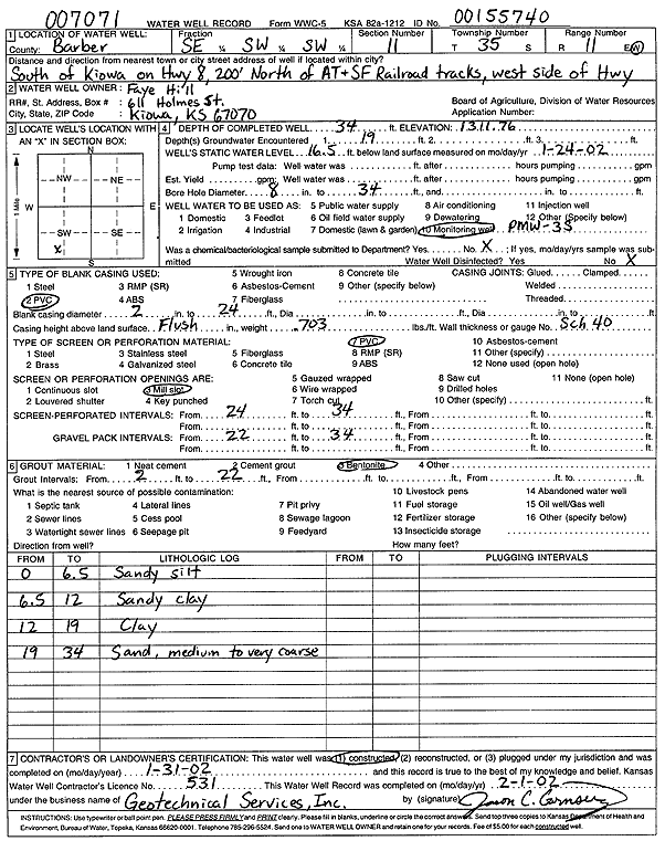
Specific Water Well Detail |
|
|
| Location Info | |||
| Owner: Hill, Faye | Status: Constructed | ||
| Location: T35S, R11W, Sec. 11, SE SW SW | County: Barber | ||
| Directions: from Kiowa: S on Hwy 8, 200' N of AT and SF RR tracks, W side of Hwy | |||
| Latitude: 37.0074337 | Longitude: -98.4907284 | Datum NAD 27 | |
| Latitude: 37.007461 | Longitude: -98.4910824 | Datum NAD 83 | |
| Longitude and latitude calculated by Survey from township-range-section-quarter calls. Only good to within the quarter call accuracy. | |||
| View well on interactive map | |||
| General Info | ||
| Well Depth: 34 ft. | Elevation: 1311.76 ft. | |
| Static Water Level: 16.5 ft. | Est. Yield: gpm. | |
| Comp. Date: 31-Jan-2002 | Well Use: Monitoring well/observation/piezometer | |
| DWR Applic. #: 007071, 00155740 | Other ID: PMW 3 S | |
| Driller Info | ||
| Driller: Geotechnical Services, Inc. | License #: 531 | |
| Scanned Form | View scan |
|
Chemical Sample Submitted?:
Water Well disinfected?: | ||
| Casing Info | ||
| Casing Type:
Casing Joints: |
Diam: in. to ft | |
| Casing height above land surface: in
Casing Weight: lbs/ft Wall thickness or gauge no.: | ||
| Screen and Perforation Info | ||
| Screen Type: | Screen Openings: | |
| Screen-perforated intervals | From: ft to ft | |
| Gravel pack intervals | From: ft to ft | |
| Grout Info | ||
| Grout used: | From: to ft | |
| Source of Possible Contamination | ||
| Source: | ||
| Direction from well: | Distance: ft | |
| Lithologic Log
(Log data entered by KGS.) | ||
| From: 0 ft. to 6.5 ft. | sandy silt | |
| From: 6.5 ft. to 12 ft. | sandy clay | |
| From: 12 ft. to 19 ft. | clay | |
| From: 19 ft. to 34 ft. | medium to very coarse sand | |