|
|
|
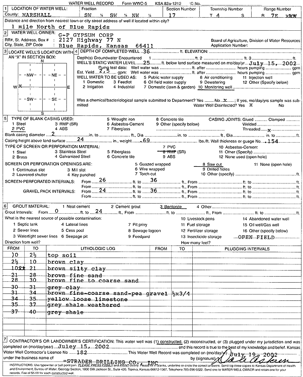
Specific Water Well Detail |
|
|
| Location Info | |||
| Owner: G-P Gypsum Corp | Status: Constructed | ||
| Location: T4S, R7E, Sec. 17, SW SW NW | County: Marshall | ||
| Directions: from Blue Rapids: 1 mi N | |||
| Latitude: 39.7051831 | Longitude: -96.6742865 | Datum NAD 27 | |
| Latitude: 39.7051839 | Longitude: -96.674582 | Datum NAD 83 | |
| Longitude and latitude calculated by Survey from township-range-section-quarter calls. Only good to within the quarter call accuracy. | |||
| View well on interactive map | |||
| General Info | ||
| Well Depth: 36 ft. | Elevation: ft. | |
| Static Water Level: 25 ft. | Est. Yield: 2.5 gpm. | |
| Comp. Date: 15-Jul-2002 | Well Use: Monitoring well/observation/piezometer | |
| DWR Applic. #: | Other ID: | |
| Driller Info | ||
| Driller: Strader Drilling Co., Inc. | License #: 182 | |
| Scanned Form | View scan |
|
Chemical Sample Submitted?:
Water Well disinfected?: | ||
| Casing Info | ||
| Casing Type:
Casing Joints: |
Diam: in. to ft | |
| Casing height above land surface: in
Casing Weight: lbs/ft Wall thickness or gauge no.: | ||
| Screen and Perforation Info | ||
| Screen Type: | Screen Openings: | |
| Screen-perforated intervals | From: ft to ft | |
| Gravel pack intervals | From: ft to ft | |
| Grout Info | ||
| Grout used: | From: to ft | |
| Source of Possible Contamination | ||
| Source: | ||
| Direction from well: | Distance: ft | |
| Lithologic Log
(Log data entered by KGS.) | ||
| From: 0 ft. to 2.5 ft. | top soil | |
| From: 2.5 ft. to 10 ft. | brown clay | |
| From: 10 ft. to 21 ft. | brown silty clay | |
| From: 21 ft. to 28 ft. | brown fine sand | |
| From: 28 ft. to 30 ft. | brown fine to coarse sand | |
| From: 30 ft. to 31 ft. | gray clay | |
| From: 31 ft. to 34 ft. | brown fine-coarse sand and pea gravel | |
| From: 34 ft. to 35 ft. | yellow loose limestone | |
| From: 35 ft. to 37 ft. | gray weathered shale | |
| From: 37 ft. to 40 ft. | gray shale | |