|
|
|
Specific Water Well Detail |
|
|
| Location Info | |||
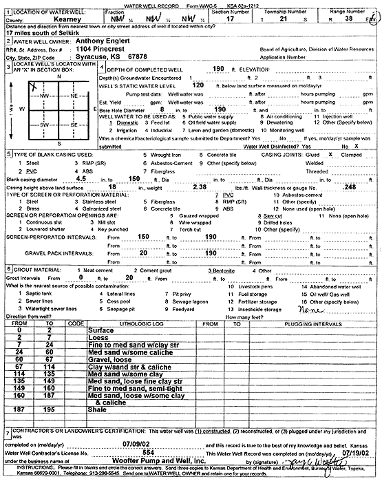
| Owner: Englert, Anthony | Status: Constructed | ||
| Location: T21S, R38W, Sec. 17, NW NW NW | County: Kearny | ||
| Directions: from Selkirk: 17 mi S | |||
| Latitude: 38.2335546 | Longitude: -101.5228335 | Datum NAD 27 | |
| Latitude: 38.233572 | Longitude: -101.5232781 | Datum NAD 83 | |
| Longitude and latitude calculated by Survey from township-range-section-quarter calls. Only good to within the quarter call accuracy. | |||
| View well on interactive map | |||
| General Info | ||
| Well Depth: 190 ft. | Elevation: ft. | |
| Static Water Level: 120 ft. | Est. Yield: gpm. | |
| Comp. Date: 09-Jul-2002 | Well Use: Domestic | |
| DWR Applic. #: | Other ID: | |
| Driller Info | ||
| Driller: Jay C. Woofter Pump & Well, Inc. | License #: 554 | |
| Scanned Form | View scan |
|
Chemical Sample Submitted?:
Water Well disinfected?: | ||
| Casing Info | ||
| Casing Type:
Casing Joints: |
Diam: in. to ft | |
| Casing height above land surface: in
Casing Weight: lbs/ft Wall thickness or gauge no.: | ||
| Screen and Perforation Info | ||
| Screen Type: | Screen Openings: | |
| Screen-perforated intervals | From: ft to ft | |
| Gravel pack intervals | From: ft to ft | |
| Grout Info | ||
| Grout used: | From: to ft | |
| Source of Possible Contamination | ||
| Source: | ||
| Direction from well: | Distance: ft | |
| Lithologic Log
(Log data entered by KGS.) | ||
| From: 0 ft. to 2 ft. | surface | |
| From: 2 ft. to 7 ft. | loess | |
| From: 7 ft. to 24 ft. | fine to medium sand with clay streak | |
| From: 24 ft. to 60 ft. | medium sand with some caliche | |
| From: 60 ft. to 67 ft. | gravel, loose | |
| From: 67 ft. to 114 ft. | clay with sand streak and caliche | |
| From: 114 ft. to 135 ft. | medium sand with some clay | |
| From: 135 ft. to 149 ft. | medium sand, loose fine clay streak | |
| From: 149 ft. to 160 ft. | fine to medium sand, semi-tight | |
| From: 160 ft. to 187 ft. | medium sand, loose with some clay and caliche | |
| From: 187 ft. to 195 ft. | shale | |