|
|
|
Specific Water Well Detail |
|
|
| Location Info | |||
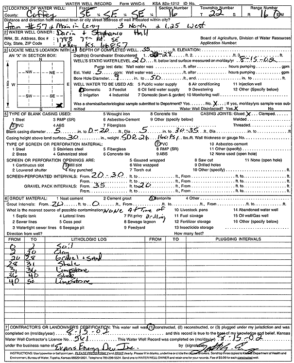
| Owner: Hall, Darin and Stephanie | Status: Constructed | ||
| Location: T22S, R16E, Sec. 16, SE SE SE | County: Coffey | ||
| Directions: from Hwy 57 and Main, LeRoy: 3 mi N, 1.25 mi W | |||
| Latitude: 38.1268154 | Longitude: -95.6477206 | Datum NAD 27 | |
| Latitude: 38.126841 | Longitude: -95.6479833 | Datum NAD 83 | |
| Longitude and latitude calculated by Survey from township-range-section-quarter calls. Only good to within the quarter call accuracy. | |||
| View well on interactive map | |||
| General Info | ||
| Well Depth: 35 ft. | Elevation: ft. | |
| Static Water Level: 20 ft. | Est. Yield: 5 gpm. | |
| Comp. Date: 15-Aug-2002 | Well Use: Domestic | |
| DWR Applic. #: | Other ID: | |
| Driller Info | ||
| Driller: Evans Energy Development, Inc. | License #: 561 | |
| Scanned Form | View scan |
|
Chemical Sample Submitted?:
Water Well disinfected?: | ||
| Casing Info | ||
| Casing Type:
Casing Joints: |
Diam: in. to ft | |
| Casing height above land surface: in
Casing Weight: lbs/ft Wall thickness or gauge no.: | ||
| Screen and Perforation Info | ||
| Screen Type: | Screen Openings: | |
| Screen-perforated intervals | From: ft to ft | |
| Gravel pack intervals | From: ft to ft | |
| Grout Info | ||
| Grout used: | From: to ft | |
| Source of Possible Contamination | ||
| Source: | ||
| Direction from well: | Distance: ft | |
| Lithologic Log
(Log data entered by KGS.) | ||
| From: 0 ft. to 2 ft. | soil | |
| From: 2 ft. to 20 ft. | clay | |
| From: 20 ft. to 28 ft. | gravel and sand | |
| From: 28 ft. to 31 ft. | shale | |
| From: 31 ft. to 36 ft. | limestone | |
| From: 36 ft. to 40 ft. | shale | |
| From: 40 ft. to 50 ft. | limestone | |