|
|
|
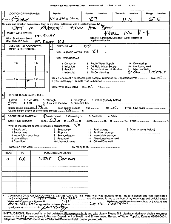
Specific Water Well Detail |
|
|
| Location Info | |||
| Owner: Fort Riley | Status: Plugged | ||
| Location: T11S, R5E, Sec. 27, NW SW SE | County: Geary | ||
| Directions: from Marshall Field Air Base | |||
| Latitude: 39.061786 | Longitude: -96.8591274 | Datum NAD 27 | |
| Latitude: 39.0617838 | Longitude: -96.8594149 | Datum NAD 83 | |
| Longitude and latitude calculated by Survey from township-range-section-quarter calls. Only good to within the quarter call accuracy. | |||
| View well on interactive map | |||
| General Info | ||
| Well Depth: 68 ft. | Elevation: ft. | |
| Static Water Level: 21 ft. | Est. Yield: gpm. | |
| Comp. Date: 10-Sep-2002 | Well Use: Environmental Remediation, Recovery | |
| DWR Applic. #: | Other ID: R 4 | |
| Driller Info | ||
| Driller: Layne Western | License #: 581 | |
| Scanned Form | View scan |
| Casing Info | ||
|
Casing Type:
Diam: in. Casing height above land surface: in | ||
| Grout Info | ||
| Grout used: | From: to ft | |
| Source of Possible Contamination | ||
| Source: | ||
| Direction from well: | Distance: ft | |