|
|
|
Specific Water Well Detail |
|
|
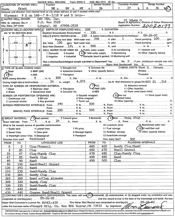
| Location Info | |||
| Owner: Oxy USA, Inc. | Status: Constructed | ||
| Location: T27S, R36W, Sec. 36, NE SW NE | County: Grant | ||
| Directions: from Ulysses: 9 mi E on 160, 7 mi N, .3 mi W, turn S | |||
| Latitude: 37.6589053 | Longitude: -101.2041948 | Datum NAD 27 | |
| Latitude: 37.6589263 | Longitude: -101.2046434 | Datum NAD 83 | |
| Longitude and latitude calculated by Survey from township-range-section-quarter calls. Only good to within the quarter call accuracy. | |||
| View well on interactive map | |||
| General Info | ||
| Well Depth: 500 ft. | Elevation: ft. | |
| Static Water Level: 330 ft. | Est. Yield: 100 gpm. | |
| Comp. Date: 26-Sep-2002 | Well Use: Oil Field Water Supply | |
| DWR Applic. #: 20020177 | Other ID: Adams O 1 | |
| Links | |
| No Wizard information available. | |
| View info from WIMAS Water Right Data base... | |
| Driller Info | ||
| Driller: Howard Drilling Company AG, LLC | License #: 430 | |
| Scanned Form | View scan |
|
Chemical Sample Submitted?:
Water Well disinfected?: | ||
| Casing Info | ||
| Casing Type:
Casing Joints: |
Diam: in. to ft | |
| Casing height above land surface: in
Casing Weight: lbs/ft Wall thickness or gauge no.: | ||
| Screen and Perforation Info | ||
| Screen Type: | Screen Openings: | |
| Screen-perforated intervals | From: ft to ft | |
| Gravel pack intervals | From: ft to ft | |
| Grout Info | ||
| Grout used: | From: to ft | |
| Source of Possible Contamination | ||
| Source: | ||
| Direction from well: | Distance: ft | |
| Lithologic Log
(Log data entered by KGS.) | ||
| From: 0 ft. to 2 ft. | Clay/Topsoil | |
| From: 2 ft. to 25 ft. | Clay | |
| From: 25 ft. to 67 ft. | clay/Sandy Clay | |
| From: 67 ft. to 85 ft. | Sandy Clay | |
| From: 85 ft. to 90 ft. | Sand | |
| From: 90 ft. to 120 ft. | Sand/Small Gravel | |
| From: 120 ft. to 193 ft. | Sand | |
| From: 193 ft. to 230 ft. | Sand/Sandy Clay | |
| From: 230 ft. to 265 ft. | Sandy Clay | |
| From: 265 ft. to 309 ft. | Sand with Clay streaks | |
| From: 309 ft. to 320 ft. | Sandy Clay | |
| From: 320 ft. to 335 ft. | Sand/Sandy Clay | |
| From: 335 ft. to 420 ft. | Sand | |
| From: 420 ft. to 440 ft. | Coarse Sand/Small Gravel | |
| From: 440 ft. to 460 ft. | Sandy Clay/Sand | |
| From: 460 ft. to 470 ft. | Small Gravel | |
| From: 470 ft. to 480 ft. | Clay/Sandy Clay | |
| From: 480 ft. to 490 ft. | Sand | |
| From: 490 ft. to 500 ft. | Clay | |