|
|
|
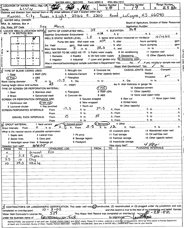
Specific Water Well Detail |
|
|
| Location Info | |||
| Owner: Kansas City Power and Light | Status: Constructed | ||
| Location: T19S, R25E, Sec. 28, NE NE NE | County: Linn | ||
| Directions: 25166 E 2200 Rd, La Cygne | |||
| Latitude: 38.3733554 | Longitude: -94.6420631 | Datum NAD 27 | |
| Latitude: 38.3733748 | Longitude: -94.642297 | Datum NAD 83 | |
| Longitude and latitude calculated by Survey from township-range-section-quarter calls. Only good to within the quarter call accuracy. | |||
| View well on interactive map | |||
| General Info | ||
| Well Depth: 38 ft. | Elevation: 868 ft. | |
| Static Water Level: 1.8 ft. | Est. Yield: gpm. | |
| Comp. Date: 03-Oct-2002 | Well Use: Monitoring well/observation/piezometer | |
| DWR Applic. #: | Other ID: MHC 5 R | |
| Driller Info | ||
| Driller: Geotechnology, Inc. | License #: 529 | |
| Scanned Form | View scan |
|
Chemical Sample Submitted?:
Water Well disinfected?: | ||
| Casing Info | ||
| Casing Type:
Casing Joints: |
Diam: in. to ft | |
| Casing height above land surface: in
Casing Weight: lbs/ft Wall thickness or gauge no.: | ||
| Screen and Perforation Info | ||
| Screen Type: | Screen Openings: | |
| Screen-perforated intervals | From: ft to ft | |
| Gravel pack intervals | From: ft to ft | |
| Grout Info | ||
| Grout used: | From: to ft | |
| Source of Possible Contamination | ||
| Source: | ||
| Direction from well: | Distance: ft | |
| Lithologic Log
(Log data entered by KGS.) | ||
| From: 0 ft. to 1 ft. | gravel | |
| From: 1 ft. to 3.5 ft. | top soil | |
| From: 3.5 ft. to 10 ft. | clay | |
| From: 10 ft. to 38.5 ft. | shale | |