|
|
|
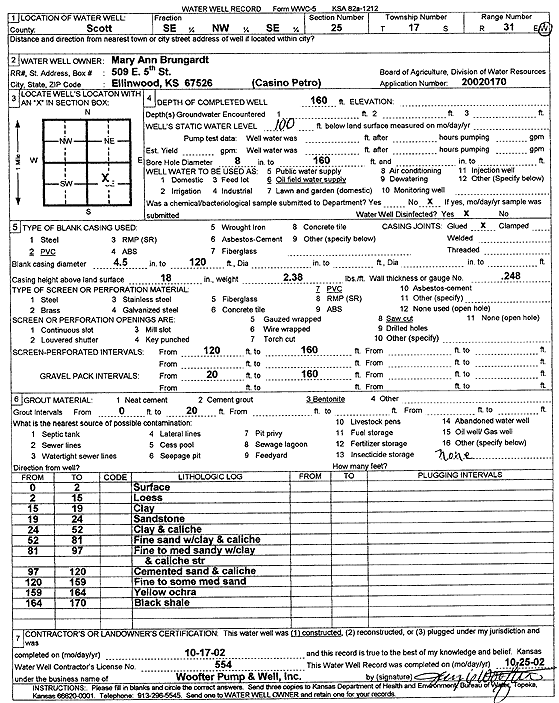
Specific Water Well Detail |
|
|
| Location Info | |||
| Owner: Brungardt, Mary Ann/Casino Petroleum | Status: Constructed | ||
| Location: T17S, R31W, Sec. 25, SE NW SE | County: Scott | ||
| Directions: | |||
| Latitude: 38.5452124 | Longitude: -100.6922378 | Datum NAD 27 | |
| Latitude: 38.5452293 | Longitude: -100.692661 | Datum NAD 83 | |
| Longitude and latitude calculated by Survey from township-range-section-quarter calls. Only good to within the quarter call accuracy. | |||
| View well on interactive map | |||
| General Info | ||
| Well Depth: 160 ft. | Elevation: ft. | |
| Static Water Level: 100 ft. | Est. Yield: gpm. | |
| Comp. Date: 17-Oct-2002 | Well Use: Oil Field Water Supply | |
| DWR Applic. #: 20020170 | Other ID: | |
| Links | |
| No Wizard information available. | |
| View info from WIMAS Water Right Data base... | |
| Driller Info | ||
| Driller: Jay C. Woofter Pump & Well, Inc. | License #: 554 | |
| Scanned Form | View scan |
|
Chemical Sample Submitted?:
Water Well disinfected?: | ||
| Casing Info | ||
| Casing Type:
Casing Joints: |
Diam: in. to ft | |
| Casing height above land surface: in
Casing Weight: lbs/ft Wall thickness or gauge no.: | ||
| Screen and Perforation Info | ||
| Screen Type: | Screen Openings: | |
| Screen-perforated intervals | From: ft to ft | |
| Gravel pack intervals | From: ft to ft | |
| Grout Info | ||
| Grout used: | From: to ft | |
| Source of Possible Contamination | ||
| Source: | ||
| Direction from well: | Distance: ft | |
| Lithologic Log
(Log data entered by KGS.) | ||
| From: 0 ft. to 2 ft. | surface | |
| From: 2 ft. to 15 ft. | loess | |
| From: 15 ft. to 19 ft. | clay | |
| From: 19 ft. to 24 ft. | sandstone | |
| From: 24 ft. to 52 ft. | clay and caliche | |
| From: 52 ft. to 81 ft. | fine sand with clay and caliche | |
| From: 81 ft. to 97 ft. | fine to med sandy with clay and caliche streak | |
| From: 97 ft. to 120 ft. | cemented sand and caliche | |
| From: 120 ft. to 159 ft. | fine to some med sand | |
| From: 159 ft. to 164 ft. | yellow ochre | |
| From: 164 ft. to 170 ft. | black shale | |