|
|
|
Specific Water Well Detail |
|
|
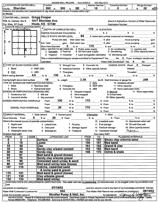
| Location Info | |||
| Owner: Cooper, Gregg | Status: Constructed | ||
| Location: T8S, R28W, Sec. 15, NW SW SE | County: Sheridan | ||
| Directions: in Hoxie | |||
| Latitude: 39.3532831 | Longitude: -100.4311997 | Datum NAD 27 | |
| Latitude: 39.353288 | Longitude: -100.4316176 | Datum NAD 83 | |
| Longitude and latitude calculated by Survey from township-range-section-quarter calls. Only good to within the quarter call accuracy. | |||
| View well on interactive map | |||
| General Info | ||
| Well Depth: 170 ft. | Elevation: ft. | |
| Static Water Level: 84 ft. | Est. Yield: gpm. | |
| Comp. Date: 19-Jul-2002 | Well Use: Domestic | |
| DWR Applic. #: | Other ID: | |
| Driller Info | ||
| Driller: Jay C. Woofter Pump & Well, Inc. | License #: 554 | |
| Scanned Form | View scan |
|
Chemical Sample Submitted?:
Water Well disinfected?: | ||
| Casing Info | ||
| Casing Type:
Casing Joints: |
Diam: in. to ft | |
| Casing height above land surface: in
Casing Weight: lbs/ft Wall thickness or gauge no.: | ||
| Screen and Perforation Info | ||
| Screen Type: | Screen Openings: | |
| Screen-perforated intervals | From: ft to ft | |
| Gravel pack intervals | From: ft to ft | |
| Grout Info | ||
| Grout used: | From: to ft | |
| Source of Possible Contamination | ||
| Source: | ||
| Direction from well: | Distance: ft | |
| Lithologic Log
(Log data entered by KGS.) | ||
| From: 0 ft. to 2 ft. | Surface | |
| From: 2 ft. to 15 ft. | Loess | |
| From: 15 ft. to 30 ft. | Clay | |
| From: 30 ft. to 40 ft. | Sandy clay with sand cement | |
| From: 40 ft. to 50 ft. | Sandy clay | |
| From: 50 ft. to 67 ft. | Medium sand and gravel loose | |
| From: 67 ft. to 75 ft. | Sandy clay with some gravel | |
| From: 75 ft. to 90 ft. | Cemented sandy with clay and sand | |
| From: 90 ft. to 107 ft. | Medium sand with clay lens loose | |
| From: 107 ft. to 115 ft. | Caliche, cemented sand and some sand and gravel | |
| From: 115 ft. to 121 ft. | Medium sand and gravel loose | |
| From: 121 ft. to 130 ft. | Clay with some gravel | |
| From: 130 ft. to 133 ft. | Medium sand with clay | |
| From: 133 ft. to 150 ft. | Sticky clay with some sand | |
| From: 150 ft. to 161 ft. | Medium sand | |
| From: 161 ft. to 162 ft. | Gravel and clay | |
| From: 162 ft. to 166 ft. | Medium sand | |
| From: 166 ft. to 170 ft. | Ochre and shale | |