|
|
|
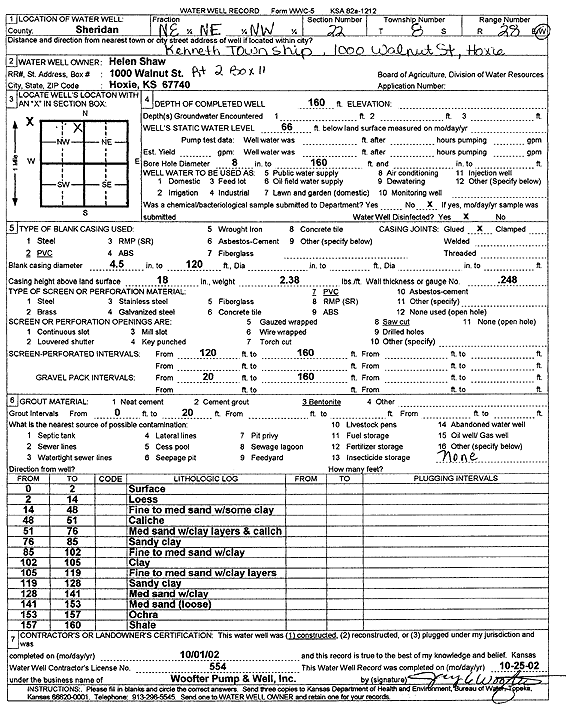
Specific Water Well Detail |
|
|
| Location Info | |||
| Owner: Shaw, Helen | Status: Constructed | ||
| Location: T8S, R28W, Sec. 22, NE NE NW | County: Sheridan | ||
| Directions: 1000 Walnut St, Kenneth Township, Hoxie | |||
| Latitude: 39.3495875 | Longitude: -100.4335273 | Datum NAD 27 | |
| Latitude: 39.3495924 | Longitude: -100.4339452 | Datum NAD 83 | |
| Longitude and latitude calculated by Survey from township-range-section-quarter calls. Only good to within the quarter call accuracy. | |||
| View well on interactive map | |||
| General Info | ||
| Well Depth: 160 ft. | Elevation: ft. | |
| Static Water Level: 66 ft. | Est. Yield: gpm. | |
| Comp. Date: 01-Oct-2002 | Well Use: Domestic | |
| DWR Applic. #: | Other ID: | |
| Driller Info | ||
| Driller: Jay C. Woofter Pump & Well, Inc. | License #: 554 | |
| Scanned Form | View scan |
|
Chemical Sample Submitted?:
Water Well disinfected?: | ||
| Casing Info | ||
| Casing Type:
Casing Joints: |
Diam: in. to ft | |
| Casing height above land surface: in
Casing Weight: lbs/ft Wall thickness or gauge no.: | ||
| Screen and Perforation Info | ||
| Screen Type: | Screen Openings: | |
| Screen-perforated intervals | From: ft to ft | |
| Gravel pack intervals | From: ft to ft | |
| Grout Info | ||
| Grout used: | From: to ft | |
| Source of Possible Contamination | ||
| Source: | ||
| Direction from well: | Distance: ft | |
| Lithologic Log
(Log data entered by KGS.) | ||
| From: 0 ft. to 2 ft. | Surface | |
| From: 2 ft. to 14 ft. | Loess | |
| From: 14 ft. to 48 ft. | Fine to medium sand with some clay | |
| From: 48 ft. to 51 ft. | Caliche | |
| From: 51 ft. to 76 ft. | Medium sand with clay layers and caliche | |
| From: 76 ft. to 85 ft. | Sandy clay | |
| From: 85 ft. to 102 ft. | Fine to medium sand with clay | |
| From: 102 ft. to 105 ft. | Clay | |
| From: 105 ft. to 119 ft. | Fine to medium sand with clay layers | |
| From: 119 ft. to 128 ft. | Sandy clay | |
| From: 128 ft. to 141 ft. | Medium sand with clay | |
| From: 141 ft. to 153 ft. | Medium sand loose | |
| From: 153 ft. to 157 ft. | Ochre | |
| From: 157 ft. to 160 ft. | Shale | |