|
|
|
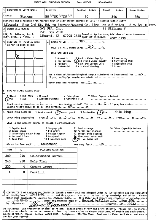
Specific Water Well Detail |
|
|
| Location Info | |||
| Owner: Oxy USA, Inc. | Status: Plugged | ||
| Location: T34S, R35W, Sec. 30, SE NE NW | County: Stevens | ||
| Directions: from Liberal: W on 2nd St to Stevens/Seward Co. line, 6 mi W, 2 mi N, .25 mi E, S into site | |||
| Latitude: 37.0658817 | Longitude: -101.1672497 | Datum NAD 27 | |
| Latitude: 37.0659074 | Longitude: -101.1676906 | Datum NAD 83 | |
| Longitude and latitude calculated by Survey from township-range-section-quarter calls. Only good to within the quarter call accuracy. | |||
| View well on interactive map | |||
| General Info | ||
| Well Depth: 380 ft. | Elevation: ft. | |
| Static Water Level: 240 ft. | Est. Yield: gpm. | |
| Comp. Date: 18-Oct-2002 | Well Use: Oil Field Water Supply | |
| DWR Applic. #: 20020130 | Other ID: Williams F-1 | |
| Links | |
| No Wizard information available. | |
| View info from WIMAS Water Right Data base... | |
| Driller Info | ||
| Driller: Howard Drilling Company AG, LLC | License #: 430 | |
| Scanned Form | View scan |
| Casing Info | ||
|
Casing Type:
Diam: in. Casing height above land surface: in | ||
| Grout Info | ||
| Grout used: | From: to ft | |
| Source of Possible Contamination | ||
| Source: | ||
| Direction from well: | Distance: ft | |