|
|
|
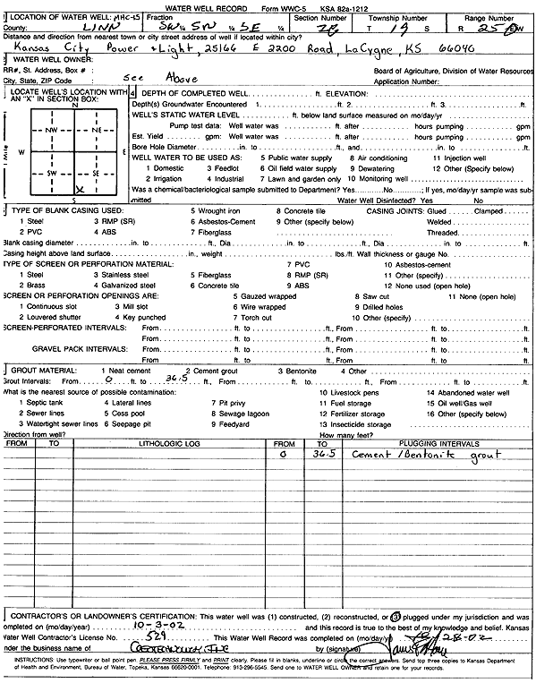
Specific Water Well Detail |
|
|
| Location Info | |||
| Owner: Kansas City Power and Light | Status: Plugged | ||
| Location: T19S, R25E, Sec. 28, SW SW SE | County: Linn | ||
| Directions: 25166 E 2200 Rd, La Cygne | |||
| Latitude: 38.3605825 | Longitude: -94.6489232 | Datum NAD 27 | |
| Latitude: 38.3606024 | Longitude: -94.6491572 | Datum NAD 83 | |
| Longitude and latitude calculated by Survey from township-range-section-quarter calls. Only good to within the quarter call accuracy. | |||
| View well on interactive map | |||
| General Info | ||
| Well Depth: 36.5 ft. | Elevation: ft. | |
| Static Water Level: ft. | Est. Yield: gpm. | |
| Comp. Date: 03-Oct-2002 | Well Use: Monitoring well/observation/piezometer | |
| DWR Applic. #: | Other ID: MHC 15 | |
| Driller Info | ||
| Driller: Geotechnology, Inc. | License #: 529 | |
| Scanned Form | View scan |
| Casing Info | ||
|
Casing Type:
Diam: in. Casing height above land surface: in | ||
| Grout Info | ||
| Grout used: | From: to ft | |
| Source of Possible Contamination | ||
| Source: | ||
| Direction from well: | Distance: ft | |