|
|
|
Specific Water Well Detail |
|
|
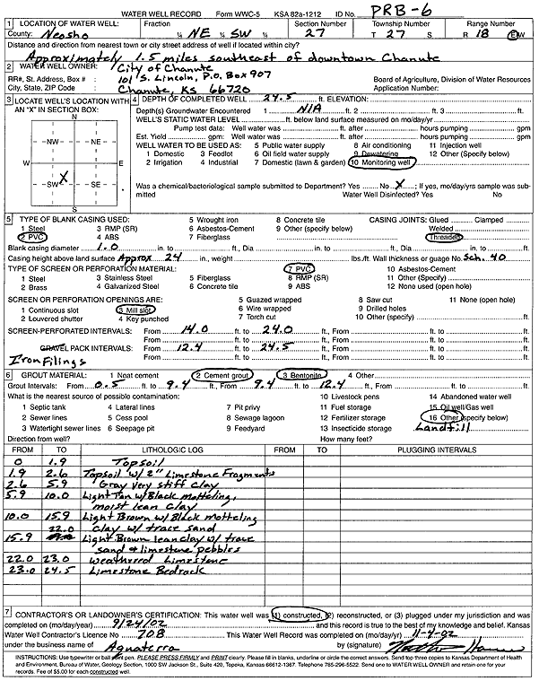
| Location Info | |||
| Owner: City of Chanute | Status: Constructed | ||
| Location: T27S, R18E, Sec. 27, NE SW | County: Neosho | ||
| Directions: from downtown Chanute: 1.5 mi SE | |||
| Latitude: 37.6657173 | Longitude: -95.4270615 | Datum NAD 27 | |
| Latitude: 37.6657647 | Longitude: -95.4273203 | Datum NAD 83 | |
| Longitude and latitude calculated by Survey from township-range-section-quarter calls. Only good to within the quarter call accuracy. | |||
| View well on interactive map | |||
| General Info | ||
| Well Depth: 24.5 ft. | Elevation: ft. | |
| Static Water Level: ft. | Est. Yield: gpm. | |
| Comp. Date: 24-Sep-2002 | Well Use: Monitoring well/observation/piezometer | |
| DWR Applic. #: | Other ID: PRB 6 | |
| Driller Info | ||
| Driller: Aquaterra Environmental Solutions, Inc. | License #: 708 | |
| Scanned Form | View scan |
|
Chemical Sample Submitted?:
Water Well disinfected?: | ||
| Casing Info | ||
| Casing Type:
Casing Joints: |
Diam: in. to ft | |
| Casing height above land surface: in
Casing Weight: lbs/ft Wall thickness or gauge no.: | ||
| Screen and Perforation Info | ||
| Screen Type: | Screen Openings: | |
| Screen-perforated intervals | From: ft to ft | |
| Gravel pack intervals | From: ft to ft | |
| Grout Info | ||
| Grout used: | From: to ft | |
| Source of Possible Contamination | ||
| Source: | ||
| Direction from well: | Distance: ft | |
| Lithologic Log
(Log data entered by KGS.) | ||
| From: 0 ft. to 1.9 ft. | top soil | |
| From: 1.9 ft. to 2.6 ft. | top soil with 2-inch limestone fragments | |
| From: 2.6 ft. to 5.9 ft. | gray very stiff clay | |
| From: 5.9 ft. to 10 ft. | lean clay, light tan with black mottling, moist | |
| From: 10 ft. to 15.9 ft. | clay with trace sand, light brown with black mottling | |
| From: 15.9 ft. to 22 ft. | lean clay with trace sand and limestone pebbles, light brown | |
| From: 22 ft. to 23 ft. | weathered limestone | |
| From: 23 ft. to 24.5 ft. | limestone bedrock | |