|
|
|
Specific Water Well Detail |
|
|
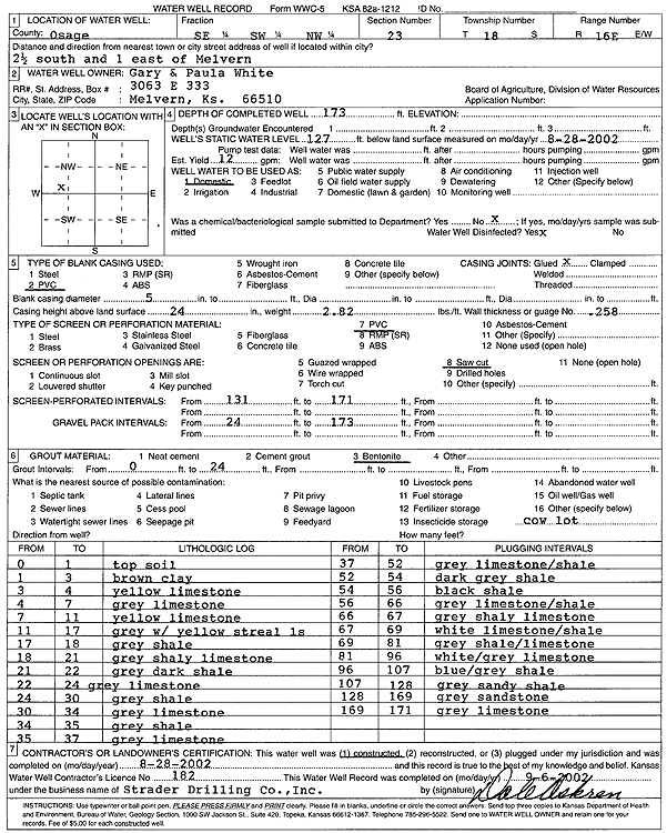
| Location Info | |||
| Owner: White, Gary and Paula | Status: Constructed | ||
| Location: T18S, R16E, Sec. 23, SE SW NW | County: Osage | ||
| Directions: from Melvern: 2.5 mi S, 1 mi E | |||
| Latitude: 38.4715108 | Longitude: -95.6154113 | Datum NAD 27 | |
| Latitude: 38.471525 | Longitude: -95.6156728 | Datum NAD 83 | |
| Longitude and latitude calculated by Survey from township-range-section-quarter calls. Only good to within the quarter call accuracy. | |||
| View well on interactive map | |||
| General Info | ||
| Well Depth: 173 ft. | Elevation: ft. | |
| Static Water Level: 127 ft. | Est. Yield: 12 gpm. | |
| Comp. Date: 28-Aug-2002 | Well Use: Domestic | |
| DWR Applic. #: | Other ID: | |
| Driller Info | ||
| Driller: Strader Drilling Co., Inc. | License #: 182 | |
| Scanned Form | View scan |
|
Chemical Sample Submitted?:
Water Well disinfected?: | ||
| Casing Info | ||
| Casing Type:
Casing Joints: |
Diam: in. to ft | |
| Casing height above land surface: in
Casing Weight: lbs/ft Wall thickness or gauge no.: | ||
| Screen and Perforation Info | ||
| Screen Type: | Screen Openings: | |
| Screen-perforated intervals | From: ft to ft | |
| Gravel pack intervals | From: ft to ft | |
| Grout Info | ||
| Grout used: | From: to ft | |
| Source of Possible Contamination | ||
| Source: | ||
| Direction from well: | Distance: ft | |
| Lithologic Log
(Log data entered by KGS.) | ||
| From: 0 ft. to 1 ft. | top soil | |
| From: 1 ft. to 3 ft. | brown clay | |
| From: 3 ft. to 4 ft. | yellow limestone | |
| From: 4 ft. to 7 ft. | gray limestone | |
| From: 7 ft. to 11 ft. | yellow limestone | |
| From: 11 ft. to 17 ft. | gray with yellow limestone streak | |
| From: 17 ft. to 18 ft. | gray shale | |
| From: 18 ft. to 21 ft. | gray shaley limestone | |
| From: 21 ft. to 22 ft. | gray dark shale | |
| From: 22 ft. to 24 ft. | gray limestone | |
| From: 24 ft. to 30 ft. | gray shale | |
| From: 30 ft. to 34 ft. | gray limestone | |
| From: 34 ft. to 35 ft. | gray shale | |
| From: 35 ft. to 37 ft. | gray limestone | |
| From: 37 ft. to 52 ft. | gray limestone and shale | |
| From: 52 ft. to 54 ft. | dark gray shale | |
| From: 54 ft. to 56 ft. | black shale | |
| From: 56 ft. to 66 ft. | gray limestone and shale | |
| From: 66 ft. to 67 ft. | gray shaley limestone | |
| From: 67 ft. to 69 ft. | white limestone and shale | |
| From: 69 ft. to 81 ft. | gray shale and limestone | |
| From: 81 ft. to 96 ft. | white and gray limestone | |
| From: 96 ft. to 107 ft. | blue-gray shale | |
| From: 107 ft. to 128 ft. | gray sandy shale | |
| From: 128 ft. to 169 ft. | gray sandstone | |
| From: 169 ft. to 171 ft. | gray limestone | |