|
|
|
Specific Water Well Detail |
|
|
| Location Info | |||
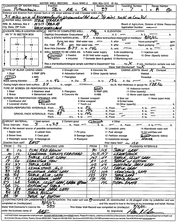
| Owner: Sterrett, Steve | Status: Constructed | ||
| Location: T7S, R8E, Sec. 29, SE NE SE | County: Pottawatomie | ||
| Directions: from Westmoreland: 3.5 mi W on Westmoreland Rd, .75 mi S on Cree Rd | |||
| Latitude: 39.4112859 | Longitude: -96.5395602 | Datum NAD 27 | |
| Latitude: 39.4112826 | Longitude: -96.5398437 | Datum NAD 83 | |
| Longitude and latitude calculated by Survey from township-range-section-quarter calls. Only good to within the quarter call accuracy. | |||
| View well on interactive map | |||
| General Info | ||
| Well Depth: 146 ft. | Elevation: ft. | |
| Static Water Level: 37 ft. | Est. Yield: 2.5 gpm. | |
| Comp. Date: 12-Aug-2002 | Well Use: Domestic | |
| DWR Applic. #: | Other ID: | |
| Driller Info | ||
| Driller: Associated Environmental, Inc. | License #: 585 | |
| Scanned Form | View scan |
|
Chemical Sample Submitted?:
Water Well disinfected?: | ||
| Casing Info | ||
| Casing Type:
Casing Joints: |
Diam: in. to ft | |
| Casing height above land surface: in
Casing Weight: lbs/ft Wall thickness or gauge no.: | ||
| Screen and Perforation Info | ||
| Screen Type: | Screen Openings: | |
| Screen-perforated intervals | From: ft to ft | |
| Gravel pack intervals | From: ft to ft | |
| Grout Info | ||
| Grout used: | From: to ft | |
| Source of Possible Contamination | ||
| Source: | ||
| Direction from well: | Distance: ft | |
| Lithologic Log
(Log data entered by KGS.) | ||
| From: 0 ft. to 10 ft. | clay, red brown | |
| From: 10 ft. to 12 ft. | cherty limestone, fractured | |
| From: 12 ft. to 19 ft. | shale, light gray | |
| From: 19 ft. to 24 ft. | limestone, tan | |
| From: 24 ft. to 37 ft. | shale, gray | |
| From: 37 ft. to 39 ft. | limestone | |
| From: 39 ft. to 48 ft. | mudstone, dark gray | |
| From: 48 ft. to 54 ft. | shale, blue gray | |
| From: 54 ft. to 57 ft. | limestone, gray | |
| From: 57 ft. to 68 ft. | shale, light gray, gray-brown | |
| From: 68 ft. to 76 ft. | gypsum with shale | |
| From: 76 ft. to 84 ft. | mudstone, dark gray | |
| From: 84 ft. to 88 ft. | shale, brown | |
| From: 88 ft. to 90 ft. | shale with gypsum | |
| From: 90 ft. to 105 ft. | shale, gray | |
| From: 105 ft. to 107 ft. | limestone | |
| From: 107 ft. to 110 ft. | shale, light gray | |
| From: 110 ft. to 112 ft. | shale with gypsum | |
| From: 112 ft. to 115 ft. | mudstone, dark gray | |
| From: 115 ft. to 121 ft. | shale, gray | |
| From: 121 ft. to 125 ft. | limestone, gray | |
| From: 125 ft. to 139 ft. | shale, gray | |
| From: 139 ft. to 146 ft. | shale, brown | |