|
|
|
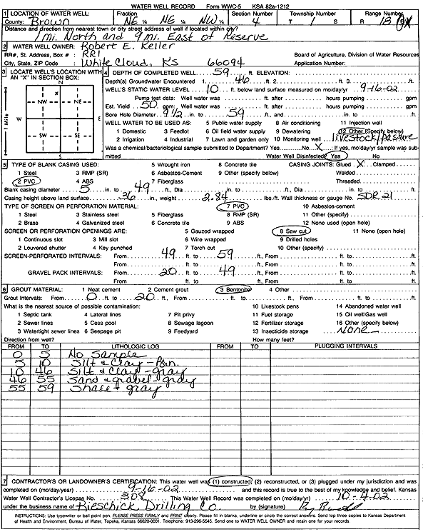
Specific Water Well Detail |
|
|
| Location Info | |||
| Owner: Keller, Robert E. | Status: Constructed | ||
| Location: T1S, R18E, Sec. 4, NE NE NW | County: Brown | ||
| Directions: from Reserve: 1 mi N, 9 mi E | |||
| Latitude: 39.9992002 | Longitude: -95.4064939 | Datum NAD 27 | |
| Latitude: 39.9992012 | Longitude: -95.4067522 | Datum NAD 83 | |
| Longitude and latitude calculated by Survey from township-range-section-quarter calls. Only good to within the quarter call accuracy. | |||
| View well on interactive map | |||
| General Info | ||
| Well Depth: 59 ft. | Elevation: ft. | |
| Static Water Level: 10 ft. | Est. Yield: 50 gpm. | |
| Comp. Date: 16-Sep-2002 | Well Use: Domestic, Livestock | |
| DWR Applic. #: | Other ID: | |
| Driller Info | ||
| Driller: Rieschick Drilling Co. | License #: 308 | |
| Scanned Form | View scan |
|
Chemical Sample Submitted?:
Water Well disinfected?: | ||
| Casing Info | ||
| Casing Type:
Casing Joints: |
Diam: in. to ft | |
| Casing height above land surface: in
Casing Weight: lbs/ft Wall thickness or gauge no.: | ||
| Screen and Perforation Info | ||
| Screen Type: | Screen Openings: | |
| Screen-perforated intervals | From: ft to ft | |
| Gravel pack intervals | From: ft to ft | |
| Grout Info | ||
| Grout used: | From: to ft | |
| Source of Possible Contamination | ||
| Source: | ||
| Direction from well: | Distance: ft | |
| Lithologic Log
(Log data entered by KGS.) | ||
| From: 0 ft. to 5 ft. | no samples | |
| From: 5 ft. to 10 ft. | silt and clay, brown | |
| From: 10 ft. to 46 ft. | silt and clay, gray | |
| From: 46 ft. to 55 ft. | sand and gravel, gray | |
| From: 55 ft. to 59 ft. | shale, gray | |