|
|
|
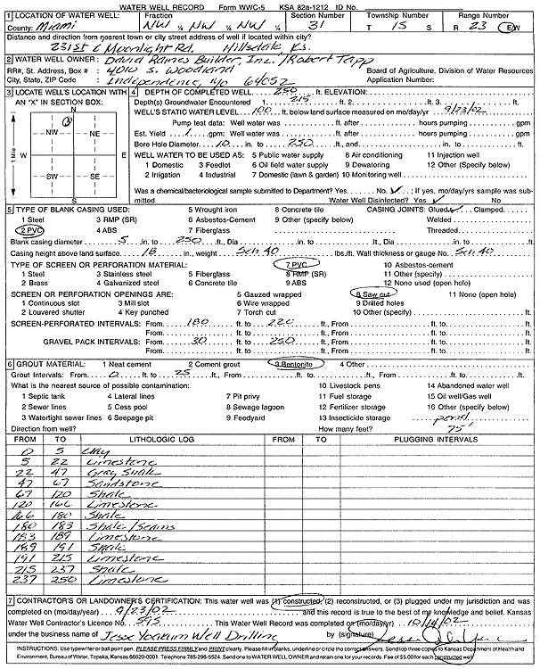
Specific Water Well Detail |
|
|
| Location Info | |||
| Owner: David Raines Builder, Inc./Robert Tapp | Status: Constructed | ||
| Location: T15S, R23E, Sec. 31, NW NW NW | County: Miami | ||
| Directions: 231st and Moonlight Rd, Hillsdale | |||
| Latitude: 38.7083277 | Longitude: -94.907062 | Datum NAD 27 | |
| Latitude: 38.7083374 | Longitude: -94.9073034 | Datum NAD 83 | |
| Longitude and latitude calculated by Survey from township-range-section-quarter calls. Only good to within the quarter call accuracy. | |||
| View well on interactive map | |||
| General Info | ||
| Well Depth: 250 ft. | Elevation: ft. | |
| Static Water Level: 100 ft. | Est. Yield: 1 gpm. | |
| Comp. Date: 23-Sep-2002 | Well Use: Domestic | |
| DWR Applic. #: | Other ID: | |
| Driller Info | ||
| Driller: Jesse Yoakum Well Drilling | License #: 595 | |
| Scanned Form | View scan |
|
Chemical Sample Submitted?:
Water Well disinfected?: | ||
| Casing Info | ||
| Casing Type:
Casing Joints: |
Diam: in. to ft | |
| Casing height above land surface: in
Casing Weight: lbs/ft Wall thickness or gauge no.: | ||
| Screen and Perforation Info | ||
| Screen Type: | Screen Openings: | |
| Screen-perforated intervals | From: ft to ft | |
| Gravel pack intervals | From: ft to ft | |
| Grout Info | ||
| Grout used: | From: to ft | |
| Source of Possible Contamination | ||
| Source: | ||
| Direction from well: | Distance: ft | |
| Lithologic Log
(Log data entered by KGS.) | ||
| From: 0 ft. to 5 ft. | Clay | |
| From: 5 ft. to 22 ft. | Limestone | |
| From: 22 ft. to 47 ft. | Shale, gray | |
| From: 47 ft. to 67 ft. | Sandstone | |
| From: 67 ft. to 120 ft. | Shale | |
| From: 120 ft. to 166 ft. | Limestone | |
| From: 166 ft. to 180 ft. | Shale | |
| From: 180 ft. to 183 ft. | Shale, seams | |
| From: 183 ft. to 189 ft. | Limestone | |
| From: 189 ft. to 191 ft. | Shale | |
| From: 191 ft. to 215 ft. | Limestone | |
| From: 215 ft. to 237 ft. | Shale | |
| From: 237 ft. to 250 ft. | Limestone | |