|
|
|
Specific Water Well Detail |
|
|
| Location Info | |||
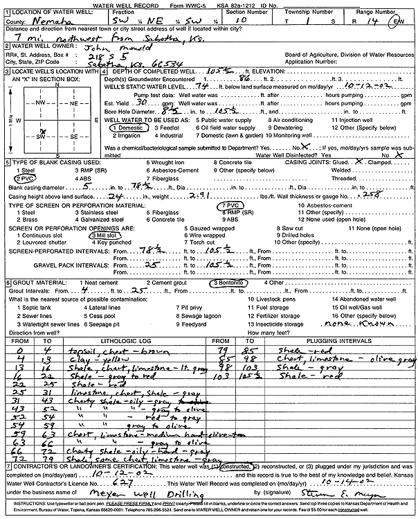
| Owner: Menold, John | Status: Constructed | ||
| Location: T1S, R14E, Sec. 10, SW NE SW | County: Nemaha | ||
| Directions: from Sabetha: 7 mi NW | |||
| Latitude: 39.9764836 | Longitude: -95.8388298 | Datum NAD 27 | |
| Latitude: 39.9764842 | Longitude: -95.8390991 | Datum NAD 83 | |
| Longitude and latitude calculated by Survey from township-range-section-quarter calls. Only good to within the quarter call accuracy. | |||
| View well on interactive map | |||
| General Info | ||
| Well Depth: 105.5 ft. | Elevation: ft. | |
| Static Water Level: 74 ft. | Est. Yield: 30 gpm. | |
| Comp. Date: 12-Oct-2002 | Well Use: Domestic | |
| DWR Applic. #: | Other ID: | |
| Driller Info | ||
| Driller: Meyer Well Drilling | License #: 627 | |
| Scanned Form | View scan |
|
Chemical Sample Submitted?:
Water Well disinfected?: | ||
| Casing Info | ||
| Casing Type:
Casing Joints: |
Diam: in. to ft | |
| Casing height above land surface: in
Casing Weight: lbs/ft Wall thickness or gauge no.: | ||
| Screen and Perforation Info | ||
| Screen Type: | Screen Openings: | |
| Screen-perforated intervals | From: ft to ft | |
| Gravel pack intervals | From: ft to ft | |
| Grout Info | ||
| Grout used: | From: to ft | |
| Source of Possible Contamination | ||
| Source: | ||
| Direction from well: | Distance: ft | |
| Lithologic Log
(Log data entered by KGS.) | ||
| From: 0 ft. to 4 ft. | top soil, chert, brown | |
| From: 4 ft. to 13 ft. | clay, yellow | |
| From: 13 ft. to 16 ft. | shale, chert, limestone, light gray | |
| From: 16 ft. to 22 ft. | shale, gray to red | |
| From: 22 ft. to 25 ft. | shale, red | |
| From: 25 ft. to 31 ft. | limestone, chert, shale, gray | |
| From: 31 ft. to 43 ft. | cherty shale, oily, gray | |
| From: 43 ft. to 52 ft. | cherty shale, oily, gray to olive | |
| From: 52 ft. to 54 ft. | cherty shale, red to gray | |
| From: 54 ft. to 59 ft. | cherty shale, gray to olive | |
| From: 59 ft. to 63 ft. | chert, limestone, medium hard, olive, tan | |
| From: 63 ft. to 66 ft. | chert, limestone, gray to olive | |
| From: 66 ft. to 72 ft. | cherty shale, oily, hard, gray | |
| From: 72 ft. to 79 ft. | shale, some chert, limestone, gray | |
| From: 79 ft. to 85 ft. | shale, red | |
| From: 85 ft. to 98 ft. | chert, limestone, olive gray | |
| From: 98 ft. to 103 ft. | shale, gray | |
| From: 103 ft. to 105.5 ft. | shale, red | |