|
|
|
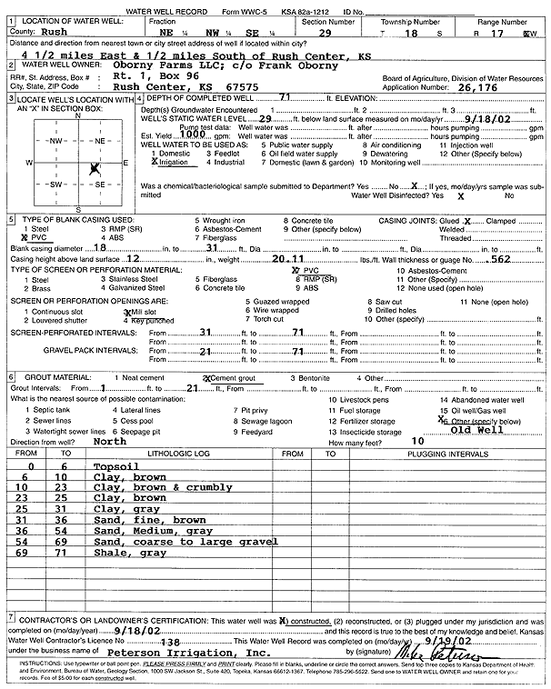
Specific Water Well Detail |
|
|
| Location Info | |||
| Owner: Oborny Farms | Status: Constructed | ||
| Location: T18S, R17W, Sec. 29, NE NW SE | County: Rush | ||
| Directions: from Rush Center: 4.5 mi E, .5 mi S | |||
| Latitude: 38.4567392 | Longitude: -99.2220846 | Datum NAD 27 | |
| Latitude: 38.4567523 | Longitude: -99.2224646 | Datum NAD 83 | |
| Longitude and latitude calculated by Survey from township-range-section-quarter calls. Only good to within the quarter call accuracy. | |||
| View well on interactive map | |||
| General Info | ||
| Well Depth: 71 ft. | Elevation: ft. | |
| Static Water Level: 29 ft. | Est. Yield: 1000 gpm. | |
| Comp. Date: 18-Sep-2002 | Well Use: Irrigation | |
| DWR Applic. #: 26176 | Other ID: | |
| Links | |
| No Wizard information available. | |
| View info from WIMAS Water Right Data base... | |
| Driller Info | ||
| Driller: Michael Peterson Irrigation, Inc. | License #: 138 | |
| Scanned Form | View scan |
|
Chemical Sample Submitted?:
Water Well disinfected?: | ||
| Casing Info | ||
| Casing Type:
Casing Joints: |
Diam: in. to ft | |
| Casing height above land surface: in
Casing Weight: lbs/ft Wall thickness or gauge no.: | ||
| Screen and Perforation Info | ||
| Screen Type: | Screen Openings: | |
| Screen-perforated intervals | From: ft to ft | |
| Gravel pack intervals | From: ft to ft | |
| Grout Info | ||
| Grout used: | From: to ft | |
| Source of Possible Contamination | ||
| Source: | ||
| Direction from well: | Distance: ft | |
| Lithologic Log
(Log data entered by KGS.) | ||
| From: 0 ft. to 6 ft. | topsoil | |
| From: 6 ft. to 10 ft. | clay, brown | |
| From: 10 ft. to 23 ft. | clay, brown and crumbly | |
| From: 23 ft. to 25 ft. | clay, brown | |
| From: 25 ft. to 31 ft. | clay, gray | |
| From: 31 ft. to 36 ft. | sand, fine, brown | |
| From: 36 ft. to 54 ft. | sand, medium, gray | |
| From: 54 ft. to 69 ft. | sand, coarse to large gravel | |
| From: 69 ft. to 71 ft. | shale, gray | |