|
|
|
Specific Water Well Detail |
|
|
| Location Info | |||
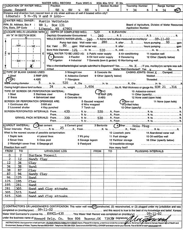
| Owner: Rustin Wettstein | Status: Constructed | ||
| Location: T34S, R34W, Sec. 4, SE SW SE | County: Seward | ||
| Directions: from Liberal: 5 mi N, 5.25 mi W & N | |||
| Latitude: 37.1130236 | Longitude: -101.0180486 | Datum NAD 27 | |
| Latitude: 37.1130491 | Longitude: -101.0184931 | Datum NAD 83 | |
| Longitude and latitude calculated by Survey from township-range-section-quarter calls. Only good to within the quarter call accuracy. | |||
| View well on interactive map | |||
| General Info | ||
| Well Depth: 520 ft. | Elevation: ft. | |
| Static Water Level: 240 ft. | Est. Yield: 80 gpm. | |
| Comp. Date: 11-Sep-2002 | Well Use: Domestic | |
| DWR Applic. #: | Other ID: | |
| Driller Info | ||
| Driller: Howard Drilling Company AG, LLC | License #: 430 | |
| Scanned Form | View scan |
|
Chemical Sample Submitted?:
Water Well disinfected?: | ||
| Casing Info | ||
| Casing Type:
Casing Joints: |
Diam: in. to ft | |
| Casing height above land surface: in
Casing Weight: lbs/ft Wall thickness or gauge no.: | ||
| Screen and Perforation Info | ||
| Screen Type: | Screen Openings: | |
| Screen-perforated intervals | From: ft to ft | |
| Gravel pack intervals | From: ft to ft | |
| Grout Info | ||
| Grout used: | From: to ft | |
| Source of Possible Contamination | ||
| Source: | ||
| Direction from well: | Distance: ft | |
| Lithologic Log
(Log data entered by KGS.) | ||
| From: 0 ft. to 2 ft. | surface topsoil | |
| From: 2 ft. to 12 ft. | sandy clay | |
| From: 12 ft. to 34 ft. | clay | |
| From: 34 ft. to 38 ft. | sand | |
| From: 38 ft. to 87 ft. | clay | |
| From: 87 ft. to 96 ft. | sandy clay | |
| From: 96 ft. to 125 ft. | sand | |
| From: 125 ft. to 195 ft. | clay | |
| From: 195 ft. to 281 ft. | sand | |
| From: 281 ft. to 305 ft. | sand and clay streaks | |
| From: 305 ft. to 515 ft. | sand | |
| From: 515 ft. to 520 ft. | sand and clay streaks | |