|
|
|
Specific Water Well Detail |
|
|
| Location Info | |||
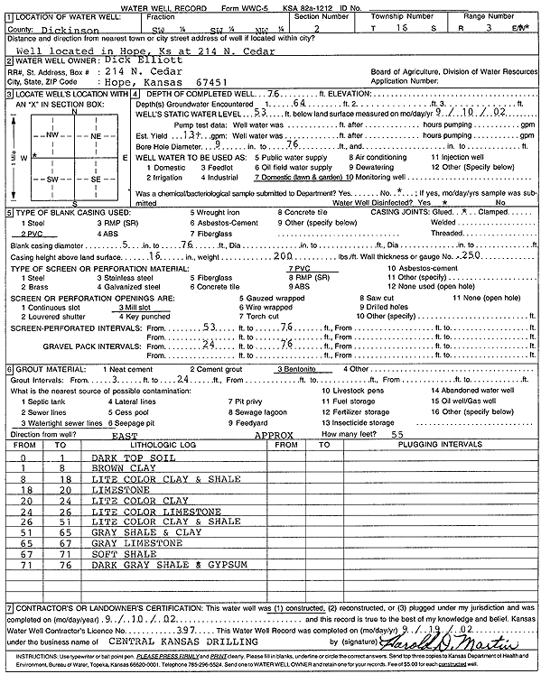
| Owner: Elliott, Dick | Status: Constructed | ||
| Location: T16S, R3E, Sec. 2, SW SW NW | County: Dickinson | ||
| Directions: 214 N Cedar, Hope | |||
| Latitude: 38.6898432 | Longitude: -97.0762647 | Datum NAD 27 | |
| Latitude: 38.6898265 | Longitude: -97.0765602 | Datum NAD 83 | |
| Longitude and latitude calculated by Survey from township-range-section-quarter calls. Only good to within the quarter call accuracy. | |||
| View well on interactive map | |||
| General Info | ||
| Well Depth: 76 ft. | Elevation: ft. | |
| Static Water Level: 53 ft. | Est. Yield: 13 gpm. | |
| Comp. Date: 10-Sep-2002 | Well Use: Domestic, Lawn and Garden | |
| DWR Applic. #: | Other ID: | |
| Driller Info | ||
| Driller: Central Kansas Drilling | License #: 397 | |
| Scanned Form | View scan |
|
Chemical Sample Submitted?:
Water Well disinfected?: | ||
| Casing Info | ||
| Casing Type:
Casing Joints: |
Diam: in. to ft | |
| Casing height above land surface: in
Casing Weight: lbs/ft Wall thickness or gauge no.: | ||
| Screen and Perforation Info | ||
| Screen Type: | Screen Openings: | |
| Screen-perforated intervals | From: ft to ft | |
| Gravel pack intervals | From: ft to ft | |
| Grout Info | ||
| Grout used: | From: to ft | |
| Source of Possible Contamination | ||
| Source: | ||
| Direction from well: | Distance: ft | |
| Lithologic Log
(Log data entered by KGS.) | ||
| From: 0 ft. to 1 ft. | dark top soil | |
| From: 1 ft. to 8 ft. | brown clay | |
| From: 8 ft. to 18 ft. | light color clay and shale | |
| From: 18 ft. to 20 ft. | limestone | |
| From: 20 ft. to 24 ft. | light color clay | |
| From: 24 ft. to 26 ft. | light color limestone | |
| From: 26 ft. to 51 ft. | light color clay and shale | |
| From: 51 ft. to 65 ft. | gray shale and clay | |
| From: 65 ft. to 67 ft. | gray limestone | |
| From: 67 ft. to 71 ft. | soft shale | |
| From: 71 ft. to 76 ft. | dark gray shale and gypsum | |