|
|
|
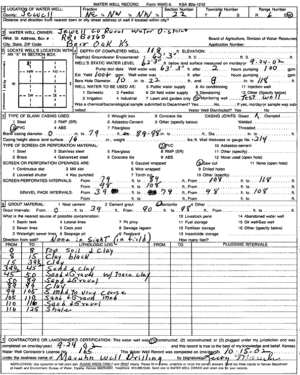
Specific Water Well Detail |
|
|
| Location Info | |||
| Owner: Jewell Co. RWD | Status: Constructed | ||
| Location: T1S, R6W, Sec. 22, NE NW NW | County: Jewell | ||
| Directions: | |||
| Latitude: 39.9564195 | Longitude: -97.9848429 | Datum NAD 27 | |
| Latitude: 39.9564326 | Longitude: -97.9851643 | Datum NAD 83 | |
| Longitude and latitude calculated by Survey from township-range-section-quarter calls. Only good to within the quarter call accuracy. | |||
| View well on interactive map | |||
| General Info | ||
| Well Depth: 118 ft. | Elevation: ft. | |
| Static Water Level: 62.25 ft. | Est. Yield: 100 gpm. | |
| Comp. Date: 24-Sep-2002 | Well Use: Test hole/well | |
| DWR Applic. #: | Other ID: | |
| Driller Info | ||
| Driller: Leroy Maruhn Well Drilling, Inc. | License #: 165 | |
| Scanned Form | View scan |
|
Chemical Sample Submitted?:
Water Well disinfected?: | ||
| Casing Info | ||
| Casing Type:
Casing Joints: |
Diam: in. to ft | |
| Casing height above land surface: in
Casing Weight: lbs/ft Wall thickness or gauge no.: | ||
| Screen and Perforation Info | ||
| Screen Type: | Screen Openings: | |
| Screen-perforated intervals | From: ft to ft | |
| Gravel pack intervals | From: ft to ft | |
| Grout Info | ||
| Grout used: | From: to ft | |
| Source of Possible Contamination | ||
| Source: | ||
| Direction from well: | Distance: ft | |
| Lithologic Log
(Log data entered by KGS.) | ||
| From: 0 ft. to 8 ft. | top soil and clay | |
| From: 8 ft. to 15 ft. | clay, black | |
| From: 15 ft. to 39.5 ft. | clay | |
| From: 39.5 ft. to 45 ft. | sand and clay | |
| From: 45 ft. to 50 ft. | sand and gravel with trace clay | |
| From: 50 ft. to 89 ft. | sand and gravel | |
| From: 89 ft. to 99 ft. | clay | |
| From: 99 ft. to 105 ft. | sand, medium to very coarse | |
| From: 105 ft. to 110 ft. | sand and gravel, medium | |
| From: 110 ft. to 116 ft. | sand and gravel | |
| From: 116 ft. to 125 ft. | shale | |