|
|
|
Specific Water Well Detail |
|
|
| Location Info | |||
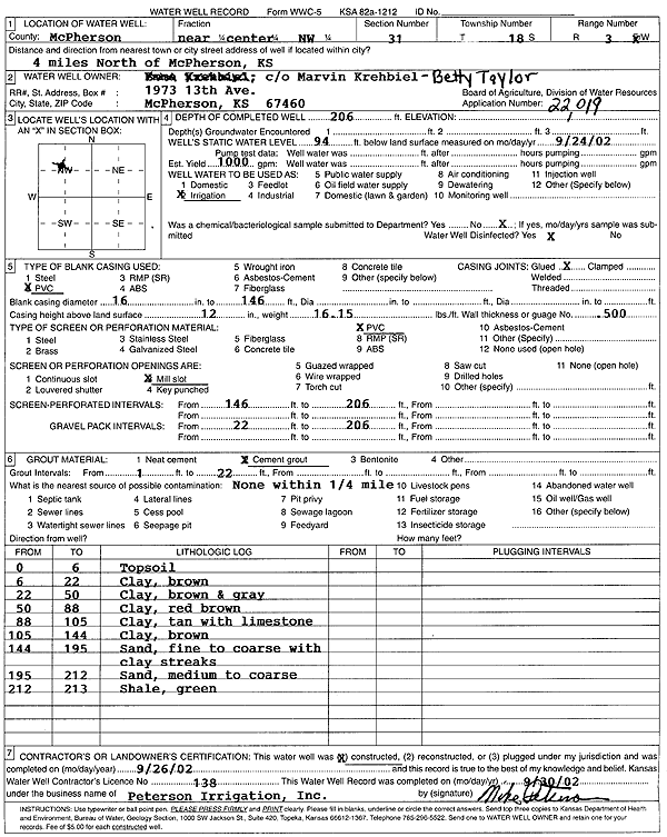
| Owner: Taylor, Betty | Status: Constructed | ||
| Location: T18S, R3W, Sec. 31, C NW | County: McPherson | ||
| Directions: from McPherson: 4 mi N | |||
| Latitude: 38.4457623 | Longitude: -97.698787 | Datum NAD 27 | |
| Latitude: 38.44577 | Longitude: -97.6991066 | Datum NAD 83 | |
| Longitude and latitude calculated by Survey from township-range-section-quarter calls. Only good to within the quarter call accuracy. | |||
| View well on interactive map | |||
| General Info | ||
| Well Depth: 206 ft. | Elevation: ft. | |
| Static Water Level: 94 ft. | Est. Yield: 1000 gpm. | |
| Comp. Date: 26-Sep-2002 | Well Use: Irrigation | |
| DWR Applic. #: 22019 | Other ID: | |
| Links | |
| No Wizard information available. | |
| View info from WIMAS Water Right Data base... | |
| Driller Info | ||
| Driller: Michael Peterson Irrigation, Inc. | License #: 138 | |
| Scanned Form | View scan |
|
Chemical Sample Submitted?:
Water Well disinfected?: | ||
| Casing Info | ||
| Casing Type:
Casing Joints: |
Diam: in. to ft | |
| Casing height above land surface: in
Casing Weight: lbs/ft Wall thickness or gauge no.: | ||
| Screen and Perforation Info | ||
| Screen Type: | Screen Openings: | |
| Screen-perforated intervals | From: ft to ft | |
| Gravel pack intervals | From: ft to ft | |
| Grout Info | ||
| Grout used: | From: to ft | |
| Source of Possible Contamination | ||
| Source: | ||
| Direction from well: | Distance: ft | |
| Lithologic Log
(Log data entered by KGS.) | ||
| From: 0 ft. to 6 ft. | top soil | |
| From: 6 ft. to 22 ft. | clay, brown | |
| From: 22 ft. to 50 ft. | clay, brown and gray | |
| From: 50 ft. to 88 ft. | clay, red brown | |
| From: 88 ft. to 105 ft. | clay, tan, with limestone | |
| From: 105 ft. to 144 ft. | clay, brown | |
| From: 144 ft. to 195 ft. | sand, fine to coarse, with clay streaks | |
| From: 195 ft. to 212 ft. | sand, medium to coarse | |
| From: 212 ft. to 213 ft. | shale, green | |