|
|
|
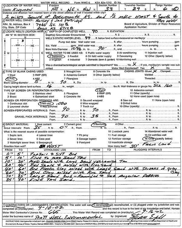
Specific Water Well Detail |
|
|
| Location Info | |||
| Owner: Partridge, Harley and Jan | Status: Constructed | ||
| Location: T29S, R6W, Sec. 33, NE NE NW | County: Kingman | ||
| Directions: from Beaumont: 2 m S, .5 mi E, S to well | |||
| Latitude: 37.4867293 | Longitude: -97.982051 | Datum NAD 27 | |
| Latitude: 37.4867461 | Longitude: -97.9823871 | Datum NAD 83 | |
| Longitude and latitude calculated by Survey from township-range-section-quarter calls. Only good to within the quarter call accuracy. | |||
| View well on interactive map | |||
| General Info | ||
| Well Depth: 90 ft. | Elevation: ft. | |
| Static Water Level: 44 ft. | Est. Yield: gpm. | |
| Comp. Date: 10-Sep-2002 | Well Use: Domestic | |
| DWR Applic. #: | Other ID: | |
| Driller Info | ||
| Driller: Pratt Well Service, Inc. | License #: 665 | |
| Scanned Form | View scan |
|
Chemical Sample Submitted?:
Water Well disinfected?: | ||
| Casing Info | ||
| Casing Type:
Casing Joints: |
Diam: in. to ft | |
| Casing height above land surface: in
Casing Weight: lbs/ft Wall thickness or gauge no.: | ||
| Screen and Perforation Info | ||
| Screen Type: | Screen Openings: | |
| Screen-perforated intervals | From: ft to ft | |
| Gravel pack intervals | From: ft to ft | |
| Grout Info | ||
| Grout used: | From: to ft | |
| Source of Possible Contamination | ||
| Source: | ||
| Direction from well: | Distance: ft | |
| Lithologic Log
(Log data entered by KGS.) | ||
| From: 0 ft. to 5 ft. | top soil and silt, brown | |
| From: 5 ft. to 10 ft. | fine to medium sand, tan | |
| From: 10 ft. to 20 ft. | medium sand with large sand, yellowish tan | |
| From: 20 ft. to 40 ft. | red shale and fine sand, mixed | |
| From: 40 ft. to 60 ft. | brown plastic clay mixed with layers of sand with streaks of gray clay | |
| From: 60 ft. to 70 ft. | brown clay mixed with fine sand | |
| From: 70 ft. to 85 ft. | large sand, subrounded and subangular pebbles | |
| From: 85 ft. to 90 ft. | fine tan sand | |