|
|
|
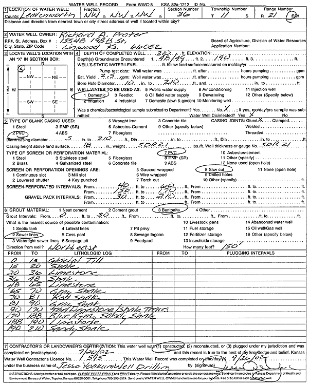
Specific Water Well Detail |
|
|
| Location Info | |||
| Owner: Prater, Richard A. | Status: Constructed | ||
| Location: T11S, R21E, Sec. 36, NW NW NW | County: Leavenworth | ||
| Directions: | |||
| Latitude: 39.0573813 | Longitude: -95.0363634 | Datum NAD 27 | |
| Latitude: 39.057384 | Longitude: -95.0366095 | Datum NAD 83 | |
| Longitude and latitude calculated by Survey from township-range-section-quarter calls. Only good to within the quarter call accuracy. | |||
| View well on interactive map | |||
| General Info | ||
| Well Depth: 210 ft. | Elevation: ft. | |
| Static Water Level: ft. | Est. Yield: 2.5 gpm. | |
| Comp. Date: 20-Jul-2002 | Well Use: Domestic | |
| DWR Applic. #: | Other ID: | |
| Driller Info | ||
| Driller: Jesse Yoakum Well Drilling | License #: 595 | |
| Scanned Form | View scan |
|
Chemical Sample Submitted?:
Water Well disinfected?: | ||
| Casing Info | ||
| Casing Type:
Casing Joints: |
Diam: in. to ft | |
| Casing height above land surface: in
Casing Weight: lbs/ft Wall thickness or gauge no.: | ||
| Screen and Perforation Info | ||
| Screen Type: | Screen Openings: | |
| Screen-perforated intervals | From: ft to ft | |
| Gravel pack intervals | From: ft to ft | |
| Grout Info | ||
| Grout used: | From: to ft | |
| Source of Possible Contamination | ||
| Source: | ||
| Direction from well: | Distance: ft | |
| Lithologic Log
(Log data entered by KGS.) | ||
| From: 0 ft. to 15 ft. | glacial till | |
| From: 15 ft. to 20 ft. | shale | |
| From: 20 ft. to 36 ft. | limestone | |
| From: 36 ft. to 48 ft. | shale | |
| From: 48 ft. to 65 ft. | limestone | |
| From: 65 ft. to 70 ft. | gray shale | |
| From: 70 ft. to 81 ft. | red shale | |
| From: 81 ft. to 90 ft. | gray shale | |
| From: 90 ft. to 170 ft. | tan limestone with shale traces | |
| From: 170 ft. to 188 ft. | blue-gray sandy shale | |
| From: 188 ft. to 190 ft. | limestone | |
| From: 190 ft. to 210 ft. | sandy shale | |