|
|
|
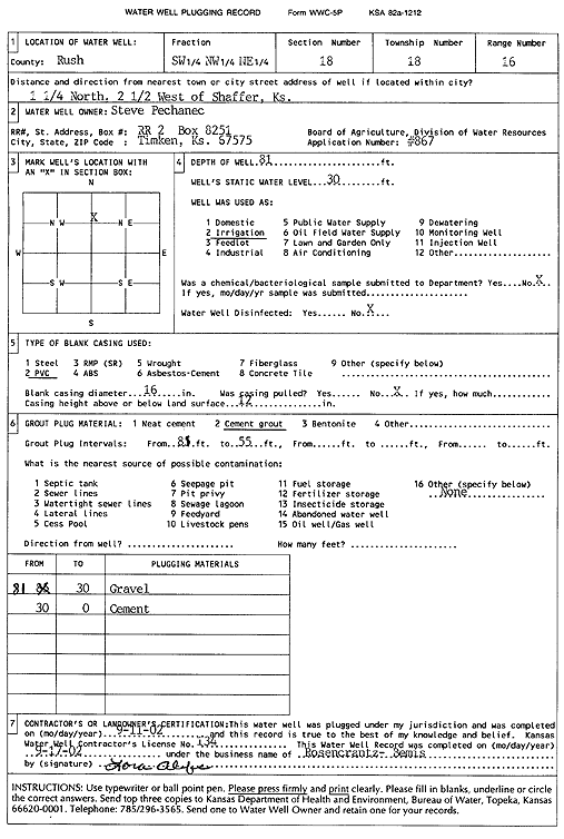
Specific Water Well Detail |
|
|
| Location Info | |||
| Owner: Pechanec, Steve | Status: Plugged | ||
| Location: T18S, R16W, Sec. 18, SW NW NE | County: Rush | ||
| Directions: from Shaffer: 1.25 mi N, 2.5 W | |||
| Latitude: 38.4910206 | Longitude: -99.13261 | Datum NAD 27 | |
| Latitude: 38.4910336 | Longitude: -99.1329861 | Datum NAD 83 | |
| Longitude and latitude calculated by Survey from township-range-section-quarter calls. Only good to within the quarter call accuracy. | |||
| View well on interactive map | |||
| General Info | ||
| Well Depth: 81 ft. | Elevation: ft. | |
| Static Water Level: 30 ft. | Est. Yield: gpm. | |
| Comp. Date: 11-Sep-2002 | Well Use: Irrigation | |
| DWR Applic. #: 867 | Other ID: | |
| Links | |
| View info from Wizard Water Level Data base... | |
| View info from WIMAS Water Right Data base... | |
| Driller Info | ||
| Driller: Rosencrantz-Bemis Enterprises, Inc. | License #: 134 | |
| Scanned Form | View scan |
| Casing Info | ||
|
Casing Type:
Diam: in. Casing height above land surface: in | ||
| Grout Info | ||
| Grout used: | From: to ft | |
| Source of Possible Contamination | ||
| Source: | ||
| Direction from well: | Distance: ft | |