|
|
|
Specific Water Well Detail |
|
|
| Location Info | |||
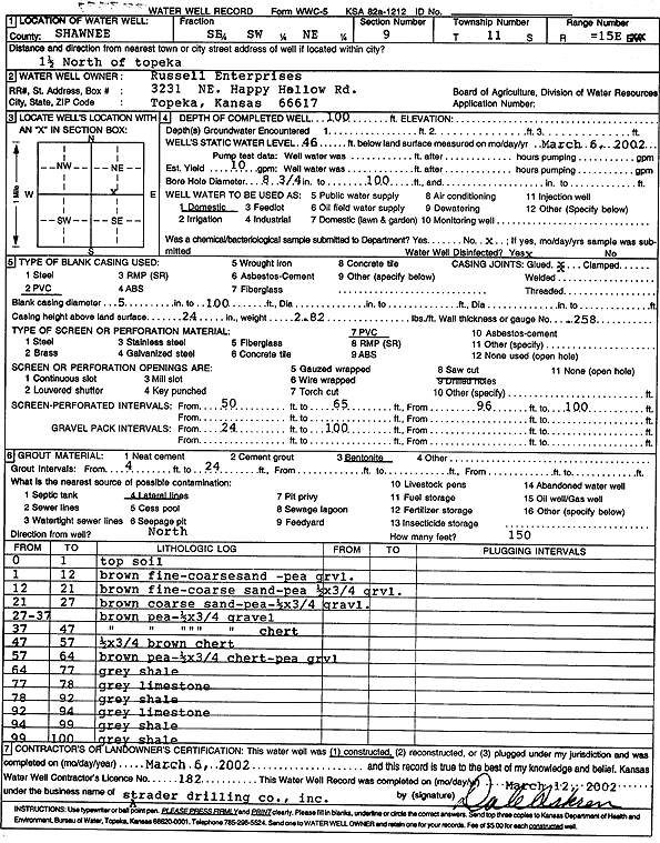
| Owner: Russell Enterprises Inc. | Status: Constructed | ||
| Location: T11S, R15E, Sec. 9, SE SW NE | County: Shawnee | ||
| Directions: from Topeka: 1.5 mi N | |||
| Latitude: 39.1099456 | Longitude: -95.7493433 | Datum NAD 27 | |
| Latitude: 39.1099449 | Longitude: -95.7496047 | Datum NAD 83 | |
| Longitude and latitude calculated by Survey from township-range-section-quarter calls. Only good to within the quarter call accuracy. | |||
| View well on interactive map | |||
| General Info | ||
| Well Depth: 100 ft. | Elevation: ft. | |
| Static Water Level: 46 ft. | Est. Yield: 10 gpm. | |
| Comp. Date: 06-Mar-2002 | Well Use: Domestic | |
| DWR Applic. #: | Other ID: | |
| Driller Info | ||
| Driller: Strader Drilling Co., Inc. | License #: 182 | |
| Scanned Form | View scan |
|
Chemical Sample Submitted?:
Water Well disinfected?: | ||
| Casing Info | ||
| Casing Type:
Casing Joints: |
Diam: in. to ft | |
| Casing height above land surface: in
Casing Weight: lbs/ft Wall thickness or gauge no.: | ||
| Screen and Perforation Info | ||
| Screen Type: | Screen Openings: | |
| Screen-perforated intervals | From: ft to ft | |
| Gravel pack intervals | From: ft to ft | |
| Grout Info | ||
| Grout used: | From: to ft | |
| Source of Possible Contamination | ||
| Source: | ||
| Direction from well: | Distance: ft | |
| Lithologic Log
(Log data entered by KGS.) | ||
| From: 0 ft. to 1 ft. | top soil | |
| From: 1 ft. to 12 ft. | brown fine-coarse sand, pea gravel | |
| From: 12 ft. to 21 ft. | brown fine-coarse sand, pea gravel, 1/2 by 3/4 gravel | |
| From: 21 ft. to 37 ft. | brown pea gravel, 1/2 by 3/4 gravel | |
| From: 37 ft. to 47 ft. | brown pea gravel, 1/2 by 3/4 gravel, chert | |
| From: 47 ft. to 57 ft. | 1/2 by 3/4 brown chert | |
| From: 57 ft. to 64 ft. | brown pea gravel, 1/2 by 3/4 chert, pea gravel | |
| From: 64 ft. to 77 ft. | gray shale | |
| From: 77 ft. to 78 ft. | gray limestone | |
| From: 78 ft. to 92 ft. | gray shale | |
| From: 92 ft. to 94 ft. | gray limestone | |
| From: 94 ft. to 99 ft. | gray shale | |
| From: 99 ft. to 100 ft. | gray shale | |