|
|
|
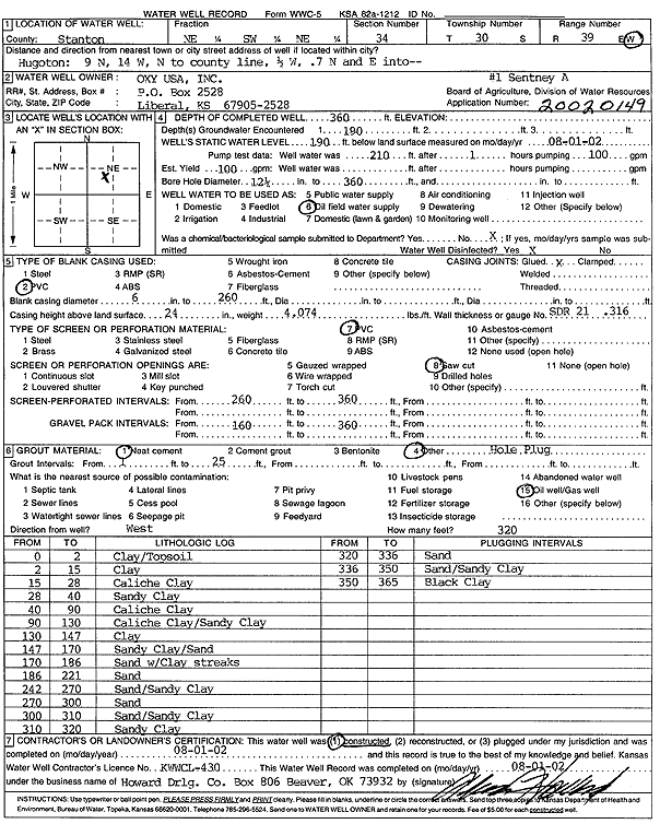
Specific Water Well Detail |
|
|
| Location Info | |||
| Owner: Oxy USA, Inc. | Status: Constructed | ||
| Location: T30S, R39W, Sec. 34, NE SW NE | County: Stanton | ||
| Directions: from Hugoton: 9 mi N, 14 mi W to Co. line, .5 mi W, .7 mi N and E into site | |||
| Latitude: 37.3984526 | Longitude: -101.5676075 | Datum NAD 27 | |
| Latitude: 37.3984744 | Longitude: -101.5680503 | Datum NAD 83 | |
| Longitude and latitude calculated by Survey from township-range-section-quarter calls. Only good to within the quarter call accuracy. | |||
| View well on interactive map | |||
| General Info | ||
| Well Depth: 360 ft. | Elevation: ft. | |
| Static Water Level: 190 ft. | Est. Yield: 100 gpm. | |
| Comp. Date: 01-Aug-2002 | Well Use: Oil Field Water Supply | |
| DWR Applic. #: 20020149 | Other ID: Sentney A-1 | |
| Links | |
| No Wizard information available. | |
| View info from WIMAS Water Right Data base... | |
| Driller Info | ||
| Driller: Howard Drilling Company AG, LLC | License #: 430 | |
| Scanned Form | View scan |
|
Chemical Sample Submitted?:
Water Well disinfected?: | ||
| Casing Info | ||
| Casing Type:
Casing Joints: |
Diam: in. to ft | |
| Casing height above land surface: in
Casing Weight: lbs/ft Wall thickness or gauge no.: | ||
| Screen and Perforation Info | ||
| Screen Type: | Screen Openings: | |
| Screen-perforated intervals | From: ft to ft | |
| Gravel pack intervals | From: ft to ft | |
| Grout Info | ||
| Grout used: | From: to ft | |
| Source of Possible Contamination | ||
| Source: | ||
| Direction from well: | Distance: ft | |
| Lithologic Log
(Log data entered by KGS.) | ||
| From: 0 ft. to 2 ft. | clay/topsoil | |
| From: 2 ft. to 15 ft. | clay | |
| From: 15 ft. to 28 ft. | caliche clay | |
| From: 28 ft. to 40 ft. | sandy clay | |
| From: 40 ft. to 90 ft. | caliche clay | |
| From: 90 ft. to 130 ft. | caliche clay/sandy clay | |
| From: 130 ft. to 147 ft. | clay | |
| From: 147 ft. to 170 ft. | sandy clay/sand | |
| From: 170 ft. to 186 ft. | sand with clay streaks | |
| From: 186 ft. to 221 ft. | sand | |
| From: 242 ft. to 270 ft. | sand/sandy clay | |
| From: 270 ft. to 300 ft. | sand | |
| From: 300 ft. to 310 ft. | sand/sandy clay | |
| From: 310 ft. to 320 ft. | sandy clay | |
| From: 320 ft. to 336 ft. | sand | |
| From: 336 ft. to 350 ft. | sand/sandy clay | |
| From: 350 ft. to 365 ft. | black clay | |