|
|
|
Specific Water Well Detail |
|
|
| Location Info | |||
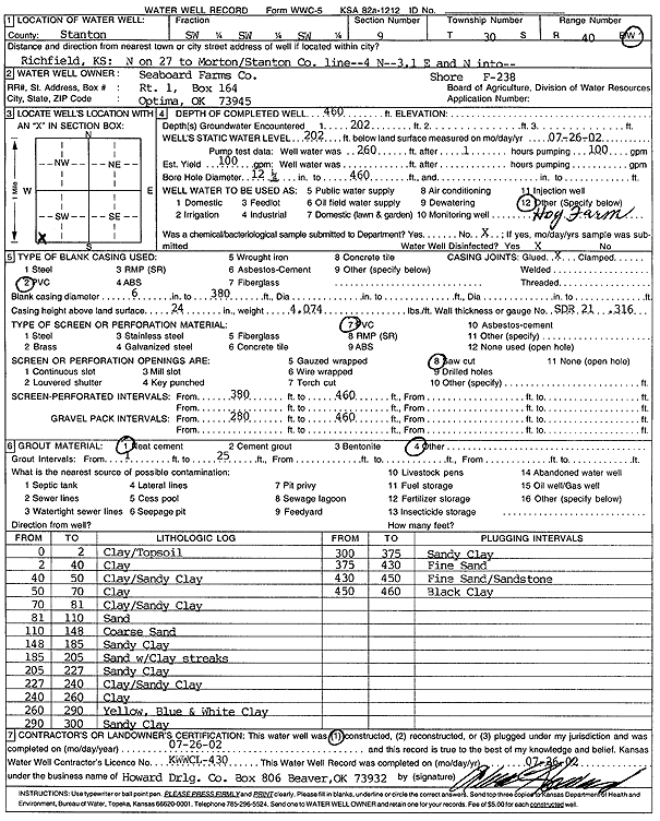
| Owner: Seaboard Farms | Status: Constructed | ||
| Location: T30S, R40W, Sec. 9, SW SW SW | County: Stanton | ||
| Directions: from Richfield: N on 27 to Morton/Stanton Co. line, 4 mi N, 3.1 mi E and N into site | |||
| Latitude: 37.4475049 | Longitude: -101.7063568 | Datum NAD 27 | |
| Latitude: 37.4475249 | Longitude: -101.7068036 | Datum NAD 83 | |
| Longitude and latitude calculated by Survey from township-range-section-quarter calls. Only good to within the quarter call accuracy. | |||
| View well on interactive map | |||
| General Info | ||
| Well Depth: 460 ft. | Elevation: ft. | |
| Static Water Level: 202 ft. | Est. Yield: 100 gpm. | |
| Comp. Date: 26-Jul-2002 | Well Use: Feedlot | |
| DWR Applic. #: | Other ID: Shore F-238 | |
| Driller Info | ||
| Driller: Howard Drilling Company AG, LLC | License #: 430 | |
| Scanned Form | View scan |
|
Chemical Sample Submitted?:
Water Well disinfected?: | ||
| Casing Info | ||
| Casing Type:
Casing Joints: |
Diam: in. to ft | |
| Casing height above land surface: in
Casing Weight: lbs/ft Wall thickness or gauge no.: | ||
| Screen and Perforation Info | ||
| Screen Type: | Screen Openings: | |
| Screen-perforated intervals | From: ft to ft | |
| Gravel pack intervals | From: ft to ft | |
| Grout Info | ||
| Grout used: | From: to ft | |
| Source of Possible Contamination | ||
| Source: | ||
| Direction from well: | Distance: ft | |
| Lithologic Log
(Log data entered by KGS.) | ||
| From: 0 ft. to 2 ft. | clay/topsoil | |
| From: 2 ft. to 40 ft. | clay | |
| From: 40 ft. to 50 ft. | clay/sandy clay | |
| From: 50 ft. to 70 ft. | clay | |
| From: 70 ft. to 81 ft. | clay/sandy clay | |
| From: 81 ft. to 110 ft. | sand | |
| From: 110 ft. to 148 ft. | coarse sand | |
| From: 148 ft. to 185 ft. | sandy clay | |
| From: 185 ft. to 205 ft. | sand with clay streaks | |
| From: 205 ft. to 227 ft. | sandy clay | |
| From: 227 ft. to 240 ft. | clay/sandy clay | |
| From: 240 ft. to 260 ft. | clay | |
| From: 260 ft. to 290 ft. | yellow, blue and white clay | |
| From: 290 ft. to 300 ft. | sandy clay | |
| From: 300 ft. to 375 ft. | sandy clay | |
| From: 375 ft. to 430 ft. | fine sand | |
| From: 430 ft. to 450 ft. | fine sand/sandstone | |
| From: 450 ft. to 460 ft. | black clay | |