|
|
|
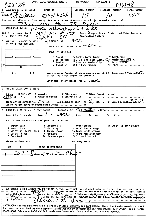
Specific Water Well Detail |
|
|
| Location Info | |||
| Owner: Waste Management of KS, Inc. | Status: Plugged | ||
| Location: T10S, R15E, Sec. 15, NE NE SW | County: Shawnee | ||
| Directions: 7351 NW Hwy 75, Topeka | |||
| Latitude: 39.1793441 | Longitude: -95.7300275 | Datum NAD 27 | |
| Latitude: 39.1793424 | Longitude: -95.7302882 | Datum NAD 83 | |
| Longitude and latitude calculated by Survey from township-range-section-quarter calls. Only good to within the quarter call accuracy. | |||
| View well on interactive map | |||
| General Info | ||
| Well Depth: 35.2 ft. | Elevation: ft. | |
| Static Water Level: 22 ft. | Est. Yield: gpm. | |
| Comp. Date: 27-Feb-2002 | Well Use: Monitoring well/observation/piezometer | |
| DWR Applic. #: | Other ID: MW 18 | |
| Driller Info | ||
| Driller: Geotechnical Services, Inc. | License #: 531 | |
| Scanned Form | View scan |
| Casing Info | ||
|
Casing Type:
Diam: in. Casing height above land surface: in | ||
| Grout Info | ||
| Grout used: | From: to ft | |
| Source of Possible Contamination | ||
| Source: | ||
| Direction from well: | Distance: ft | |