|
|
|
Specific Water Well Detail |
|
|
| Location Info | |||
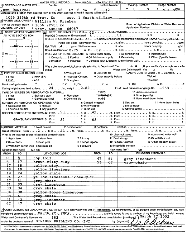
| Owner: Franken, William W. | Status: Constructed | ||
| Location: T3S, R20E, Sec. 12, SE SW NW | County: Doniphan | ||
| Directions: 1056 225th Rd, Troy - from Troy: 1 mi N | |||
| Latitude: 39.8062918 | Longitude: -95.1302269 | Datum NAD 27 | |
| Latitude: 39.806288 | Longitude: -95.1304779 | Datum NAD 83 | |
| Longitude and latitude calculated by Survey from township-range-section-quarter calls. Only good to within the quarter call accuracy. | |||
| View well on interactive map | |||
| General Info | ||
| Well Depth: 62 ft. | Elevation: ft. | |
| Static Water Level: 23 ft. | Est. Yield: 4 gpm. | |
| Comp. Date: 22-Mar-2002 | Well Use: Domestic | |
| DWR Applic. #: | Other ID: | |
| Driller Info | ||
| Driller: Strader Drilling Co., Inc. | License #: 182 | |
| Scanned Form | View scan |
|
Chemical Sample Submitted?:
Water Well disinfected?: | ||
| Casing Info | ||
| Casing Type:
Casing Joints: |
Diam: in. to ft | |
| Casing height above land surface: in
Casing Weight: lbs/ft Wall thickness or gauge no.: | ||
| Screen and Perforation Info | ||
| Screen Type: | Screen Openings: | |
| Screen-perforated intervals | From: ft to ft | |
| Gravel pack intervals | From: ft to ft | |
| Grout Info | ||
| Grout used: | From: to ft | |
| Source of Possible Contamination | ||
| Source: | ||
| Direction from well: | Distance: ft | |
| Lithologic Log
(Log data entered by KGS.) | ||
| From: 0 ft. to .5 ft. | Top soil | |
| From: .5 ft. to 17 ft. | Silty clay, brown | |
| From: 17 ft. to 18 ft. | Clay, yellow | |
| From: 18 ft. to 19 ft. | Limestone, yellow | |
| From: 19 ft. to 24 ft. | Shale, yellow | |
| From: 24 ft. to 27 ft. | Limestone, yellow, loose at 26 | |
| From: 27 ft. to 31 ft. | Shale, gray | |
| From: 31 ft. to 33 ft. | Limestone, gray | |
| From: 33 ft. to 34 ft. | Shale, gray | |
| From: 34 ft. to 38 ft. | Limestone, loose, yellow | |
| From: 38 ft. to 41 ft. | Shale, gray | |
| From: 41 ft. to 42 ft. | Limestone, gray | |
| From: 42 ft. to 47 ft. | Shale, gray | |
| From: 47 ft. to 51 ft. | Limestone, gray | |
| From: 51 ft. to 62 ft. | Shale, gray | |