|
|
|
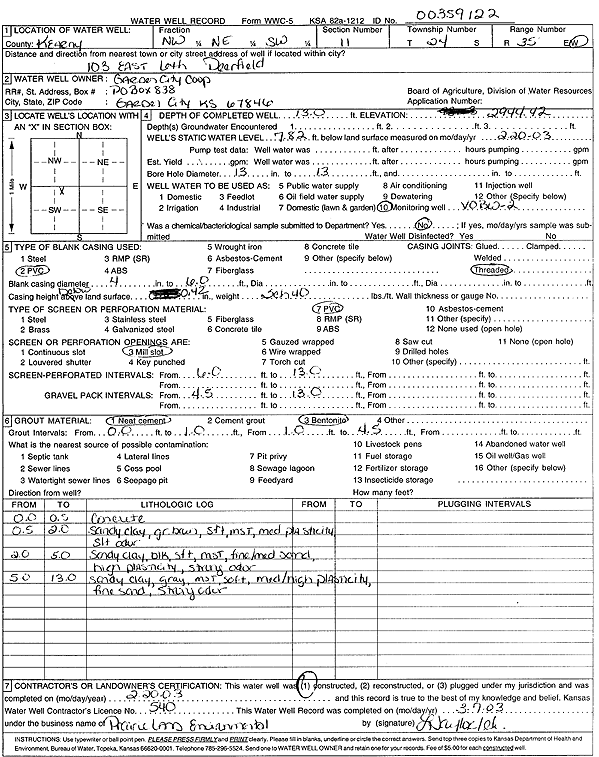
Specific Water Well Detail |
|
|
| Location Info | |||
| Owner: Garden City Coop | Status: Constructed | ||
| Location: T24S, R35W, Sec. 11, NW NE SW | County: Kearny | ||
| Directions: 103 E 6th, Deerfield (tag 00359122) | |||
| Latitude: 37.9802766 | Longitude: -101.1331956 | Datum NAD 27 | |
| Latitude: 37.9802987 | Longitude: -101.1336417 | Datum NAD 83 | |
| Longitude and latitude calculated by Survey from township-range-section-quarter calls. Only good to within the quarter call accuracy. | |||
| View well on interactive map | |||
| General Info | ||
| Well Depth: 13 ft. | Elevation: 2944.42 ft. | |
| Static Water Level: 7.82 ft. | Est. Yield: gpm. | |
| Comp. Date: 20-Feb-2003 | Well Use: Monitoring well/observation/piezometer | |
| DWR Applic. #: | Other ID: VOBW 2 | |
| Driller Info | ||
| Driller: Prairie Land Environmental Remed. | License #: 540 | |
| Scanned Form | View scan |
|
Chemical Sample Submitted?:
Water Well disinfected?: | ||
| Casing Info | ||
| Casing Type:
Casing Joints: |
Diam: in. to ft | |
| Casing height above land surface: in
Casing Weight: lbs/ft Wall thickness or gauge no.: | ||
| Screen and Perforation Info | ||
| Screen Type: | Screen Openings: | |
| Screen-perforated intervals | From: ft to ft | |
| Gravel pack intervals | From: ft to ft | |
| Grout Info | ||
| Grout used: | From: to ft | |
| Source of Possible Contamination | ||
| Source: | ||
| Direction from well: | Distance: ft | |
| Lithologic Log
(Log data entered by KGS.) | ||
| From: 0 ft. to .5 ft. | concrete | |
| From: .5 ft. to 2 ft. | sandy clay, gray brown, soft, moist, medium plasticity, slight odor | |
| From: 2 ft. to 5 ft. | sandy clay, black, soft, moist, fine/medium sand, high plasticity, strong odor | |
| From: 5 ft. to 13 ft. | sandy clay, gray, moist, soft, medium/high plasticity, fine sand, strong odor | |