|
|
|
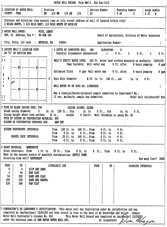
Specific Water Well Detail |
|
|
| Location Info | |||
| Owner: Vice, Leroy | Status: Constructed | ||
| Location: T28S, R21W, Sec. 22, SW NW SW | County: Ford | ||
| Directions: from Bucklin: 2 mi N, 1.25 mi E, .5 mi N | |||
| Latitude: 37.5910239 | Longitude: -99.6110197 | Datum NAD 27 | |
| Latitude: 37.591044 | Longitude: -99.6114202 | Datum NAD 83 | |
| Longitude and latitude calculated by Survey from township-range-section-quarter calls. Only good to within the quarter call accuracy. | |||
| View well on interactive map | |||
| General Info | ||
| Well Depth: 140 ft. | Elevation: ft. | |
| Static Water Level: 103 ft. | Est. Yield: gpm. | |
| Comp. Date: 01-Dec-2002 | Well Use: Domestic, Livestock | |
| DWR Applic. #: | Other ID: | |
| Driller Info | ||
| Driller: Dan Hayse Water Well Service | License #: 653 | |
| Scanned Form | View scan |
|
Chemical Sample Submitted?:
Water Well disinfected?: | ||
| Casing Info | ||
| Casing Type:
Casing Joints: |
Diam: in. to ft | |
| Casing height above land surface: in
Casing Weight: lbs/ft Wall thickness or gauge no.: | ||
| Screen and Perforation Info | ||
| Screen Type: | Screen Openings: | |
| Screen-perforated intervals | From: ft to ft | |
| Gravel pack intervals | From: ft to ft | |
| Grout Info | ||
| Grout used: | From: to ft | |
| Source of Possible Contamination | ||
| Source: | ||
| Direction from well: | Distance: ft | |
| Lithologic Log
(Log data entered by KGS.) | ||
| From: 0 ft. to 6 ft. | silt and sand | |
| From: 6 ft. to 54 ft. | tan clay | |
| From: 54 ft. to 118 ft. | sand and clay | |
| From: 118 ft. to 138 ft. | sand and gravel | |
| From: 138 ft. to 140 ft. | tan clay | |