|
|
|
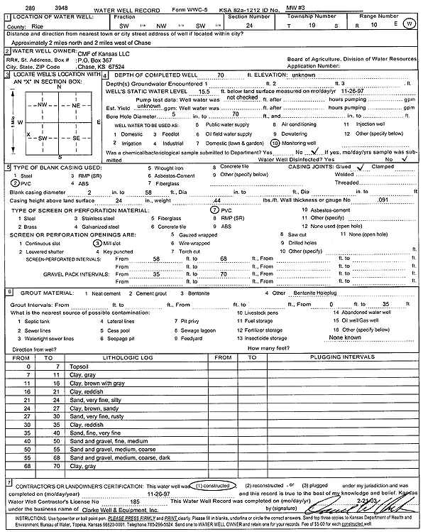
Specific Water Well Detail |
|
|
| Location Info | |||
| Owner: CMF of Kansas, LLC | Status: Constructed | ||
| Location: T19S, R10W, Sec. 24, SW NW SW | County: Rice | ||
| Directions: from Chase: 2 mi N, 2 mi W | |||
| Latitude: 38.3812313 | Longitude: -98.386354 | Datum NAD 27 | |
| Latitude: 38.3812423 | Longitude: -98.3867 | Datum NAD 83 | |
| Longitude and latitude calculated by Survey from township-range-section-quarter calls. Only good to within the quarter call accuracy. | |||
| View well on interactive map | |||
| General Info | ||
| Well Depth: 70 ft. | Elevation: ft. | |
| Static Water Level: 15.5 ft. | Est. Yield: gpm. | |
| Comp. Date: 26-Nov-1997 | Well Use: Monitoring well/observation/piezometer | |
| DWR Applic. #: | Other ID: MW 3 | |
| Driller Info | ||
| Driller: Clarke Well and Equipment, Inc. | License #: 185 | |
| Scanned Form | View scan |
|
Chemical Sample Submitted?:
Water Well disinfected?: | ||
| Casing Info | ||
| Casing Type:
Casing Joints: |
Diam: in. to ft | |
| Casing height above land surface: in
Casing Weight: lbs/ft Wall thickness or gauge no.: | ||
| Screen and Perforation Info | ||
| Screen Type: | Screen Openings: | |
| Screen-perforated intervals | From: ft to ft | |
| Gravel pack intervals | From: ft to ft | |
| Grout Info | ||
| Grout used: | From: to ft | |
| Source of Possible Contamination | ||
| Source: | ||
| Direction from well: | Distance: ft | |
| Lithologic Log
(Log data entered by KGS.) | ||
| From: 0 ft. to 7 ft. | top soil | |
| From: 7 ft. to 11 ft. | clay, gray | |
| From: 11 ft. to 16 ft. | clay, brown with gray | |
| From: 16 ft. to 21 ft. | clay, reddish | |
| From: 21 ft. to 24 ft. | very fine sand, silty | |
| From: 24 ft. to 27 ft. | sandy clay, brown | |
| From: 27 ft. to 30 ft. | very fine sand, rusty | |
| From: 30 ft. to 35 ft. | clay, reddish | |
| From: 35 ft. to 40 ft. | fine-very fine sand | |
| From: 40 ft. to 50 ft. | fine-medium sand and gravel | |
| From: 50 ft. to 55 ft. | medium-coarse sand and gravel | |
| From: 55 ft. to 68 ft. | sand and gravel; medium, coarse, dark | |
| From: 68 ft. to 70 ft. | clay, gray | |