|
|
|
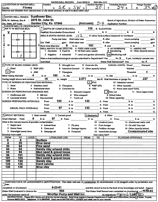
Specific Water Well Detail |
|
|
| Location Info | |||
| Owner: Sunflower Electric Power Corp. | Status: Constructed | ||
| Location: T24S, R33W, Sec. 20, SE SW | County: Finney | ||
| Directions: | |||
| Latitude: 37.9475207 | Longitude: -100.9677971 | Datum NAD 27 | |
| Latitude: 37.9475447 | Longitude: -100.9682408 | Datum NAD 83 | |
| Longitude and latitude calculated by Survey from township-range-section-quarter calls. Only good to within the quarter call accuracy. | |||
| View well on interactive map | |||
| General Info | ||
| Well Depth: 130 ft. | Elevation: ft. | |
| Static Water Level: 112 ft. | Est. Yield: gpm. | |
| Comp. Date: 23-Sep-2001 | Well Use: Monitoring well/observation/piezometer | |
| DWR Applic. #: | Other ID: S 4 | |
| Driller Info | ||
| Driller: Jay C. Woofter Pump & Well, Inc. | License #: 554 | |
| Scanned Form | View scan |
|
Chemical Sample Submitted?:
Water Well disinfected?: | ||
| Casing Info | ||
| Casing Type:
Casing Joints: |
Diam: in. to ft | |
| Casing height above land surface: in
Casing Weight: lbs/ft Wall thickness or gauge no.: | ||
| Screen and Perforation Info | ||
| Screen Type: | Screen Openings: | |
| Screen-perforated intervals | From: ft to ft | |
| Gravel pack intervals | From: ft to ft | |
| Grout Info | ||
| Grout used: | From: to ft | |
| Source of Possible Contamination | ||
| Source: | ||
| Direction from well: | Distance: ft | |
| Lithologic Log
(Log data entered by KGS.) | ||
| From: 0 ft. to .6 ft. | surface | |
| From: .6 ft. to 20 ft. | blue sand | |
| From: 20 ft. to 64 ft. | fine sand | |
| From: 64 ft. to 69 ft. | sandy clay with sand streaks | |
| From: 69 ft. to 94 ft. | medium sand and gravel loose | |
| From: 94 ft. to 101 ft. | sandy clay with sand streaks | |
| From: 101 ft. to 109 ft. | medium sand and gravel loose | |
| From: 109 ft. to 124 ft. | sandy clay | |
| From: 124 ft. to 125 ft. | hard caliche | |
| From: 125 ft. to 130 ft. | blue clay | |