|
|
|
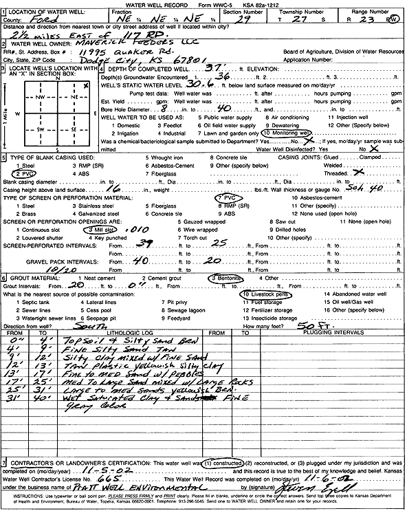
Specific Water Well Detail |
|
|
| Location Info | |||
| Owner: Maverick Feeders LLC | Status: Constructed | ||
| Location: T27S, R23W, Sec. 29, NE NE NE | County: Ford | ||
| Directions: from 117 Rd: 2.5 mi E | |||
| Latitude: 37.6757151 | Longitude: -99.8530961 | Datum NAD 27 | |
| Latitude: 37.6757354 | Longitude: -99.8535038 | Datum NAD 83 | |
| Longitude and latitude calculated by Survey from township-range-section-quarter calls. Only good to within the quarter call accuracy. | |||
| View well on interactive map | |||
| General Info | ||
| Well Depth: 37 ft. | Elevation: ft. | |
| Static Water Level: 30.6 ft. | Est. Yield: gpm. | |
| Comp. Date: 05-Nov-2002 | Well Use: Monitoring well/observation/piezometer | |
| DWR Applic. #: | Other ID: | |
| Driller Info | ||
| Driller: Pratt Well Service, Inc. | License #: 665 | |
| Scanned Form | View scan |
|
Chemical Sample Submitted?:
Water Well disinfected?: | ||
| Casing Info | ||
| Casing Type:
Casing Joints: |
Diam: in. to ft | |
| Casing height above land surface: in
Casing Weight: lbs/ft Wall thickness or gauge no.: | ||
| Screen and Perforation Info | ||
| Screen Type: | Screen Openings: | |
| Screen-perforated intervals | From: ft to ft | |
| Gravel pack intervals | From: ft to ft | |
| Grout Info | ||
| Grout used: | From: to ft | |
| Source of Possible Contamination | ||
| Source: | ||
| Direction from well: | Distance: ft | |
| Lithologic Log
(Log data entered by KGS.) | ||
| From: 0 ft. to .3 ft. | topsoil and silty sand brown | |
| From: .3 ft. to 9 ft. | fine silty sand tan | |
| From: 9 ft. to 12 ft. | silty clay mixed with fine sand | |
| From: 12 ft. to 13 ft. | tan plastic yellowish silty clay | |
| From: 13 ft. to 17 ft. | fine to medium sand with pebbles | |
| From: 17 ft. to 25 ft. | medium to large sand mixed with large rocks | |
| From: 25 ft. to 31 ft. | large to medium sands yellowish brown | |
| From: 31 ft. to 40 ft. | wet saturated clay and sands fine gray color | |