|
|
|
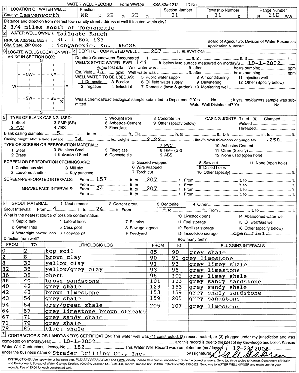
Specific Water Well Detail |
|
|
| Location Info | |||
| Owner: Tailgate Ranch | Status: Constructed | ||
| Location: T11S, R21E, Sec. 21, NE SE SE | County: Leavenworth | ||
| Directions: from Tonganoxie: 2.75 mi S | |||
| Latitude: 39.0756723 | Longitude: -95.075822 | Datum NAD 27 | |
| Latitude: 39.0756745 | Longitude: -95.0760686 | Datum NAD 83 | |
| Longitude and latitude calculated by Survey from township-range-section-quarter calls. Only good to within the quarter call accuracy. | |||
| View well on interactive map | |||
| General Info | ||
| Well Depth: 207 ft. | Elevation: ft. | |
| Static Water Level: 144 ft. | Est. Yield: 15 gpm. | |
| Comp. Date: 01-Oct-2002 | Well Use: Domestic | |
| DWR Applic. #: | Other ID: | |
| Driller Info | ||
| Driller: Strader Drilling Co., Inc. | License #: 182 | |
| Scanned Form | View scan |
|
Chemical Sample Submitted?:
Water Well disinfected?: | ||
| Casing Info | ||
| Casing Type:
Casing Joints: |
Diam: in. to ft | |
| Casing height above land surface: in
Casing Weight: lbs/ft Wall thickness or gauge no.: | ||
| Screen and Perforation Info | ||
| Screen Type: | Screen Openings: | |
| Screen-perforated intervals | From: ft to ft | |
| Gravel pack intervals | From: ft to ft | |
| Grout Info | ||
| Grout used: | From: to ft | |
| Source of Possible Contamination | ||
| Source: | ||
| Direction from well: | Distance: ft | |
| Lithologic Log
(Log data entered by KGS.) | ||
| From: 0 ft. to 2 ft. | top soil | |
| From: 2 ft. to 8 ft. | brown clay | |
| From: 8 ft. to 32 ft. | yellow clay | |
| From: 32 ft. to 36 ft. | yellow-gray clay | |
| From: 36 ft. to 38 ft. | chert | |
| From: 38 ft. to 40 ft. | brown sandstone | |
| From: 40 ft. to 42 ft. | gray shale | |
| From: 42 ft. to 43 ft. | brown limestone | |
| From: 43 ft. to 54 ft. | gray shale | |
| From: 54 ft. to 64 ft. | gray-green shale | |
| From: 64 ft. to 67 ft. | gray limestone brown streaks | |
| From: 67 ft. to 71 ft. | gray sandy shale | |
| From: 71 ft. to 79 ft. | gray shale | |
| From: 79 ft. to 85 ft. | black shale | |
| From: 85 ft. to 90 ft. | gray shale | |
| From: 90 ft. to 91 ft. | gray limestone | |
| From: 91 ft. to 93 ft. | gray limey shale | |
| From: 93 ft. to 96 ft. | gray limestone | |
| From: 96 ft. to 101 ft. | gray limey shale | |
| From: 101 ft. to 123 ft. | gray sandy sandstone | |
| From: 123 ft. to 153 ft. | gray sandy shale | |
| From: 153 ft. to 159 ft. | gray shaley sandstone | |
| From: 159 ft. to 205 ft. | gray sandstone | |
| From: 205 ft. to 207 ft. | gray limestone | |