|
|
|
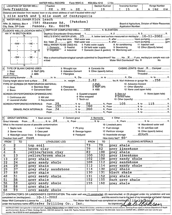
Specific Water Well Detail |
|
|
| Location Info | |||
| Owner: Leach, Rick | Status: Constructed | ||
| Location: T15S, R19E, Sec. 19, NE NE SE | County: Franklin | ||
| Directions: from Centropolis: .5 mi N, .5 mi E | |||
| Latitude: 38.730507 | Longitude: -95.3354262 | Datum NAD 27 | |
| Latitude: 38.7305145 | Longitude: -95.3356794 | Datum NAD 83 | |
| Longitude and latitude calculated by Survey from township-range-section-quarter calls. Only good to within the quarter call accuracy. | |||
| View well on interactive map | |||
| General Info | ||
| Well Depth: 160 ft. | Elevation: ft. | |
| Static Water Level: 25 ft. | Est. Yield: 2 gpm. | |
| Comp. Date: 11-Oct-2002 | Well Use: Domestic | |
| DWR Applic. #: | Other ID: | |
| Driller Info | ||
| Driller: Strader Drilling Co., Inc. | License #: 182 | |
| Scanned Form | View scan |
|
Chemical Sample Submitted?:
Water Well disinfected?: | ||
| Casing Info | ||
| Casing Type:
Casing Joints: |
Diam: in. to ft | |
| Casing height above land surface: in
Casing Weight: lbs/ft Wall thickness or gauge no.: | ||
| Screen and Perforation Info | ||
| Screen Type: | Screen Openings: | |
| Screen-perforated intervals | From: ft to ft | |
| Gravel pack intervals | From: ft to ft | |
| Grout Info | ||
| Grout used: | From: to ft | |
| Source of Possible Contamination | ||
| Source: | ||
| Direction from well: | Distance: ft | |
| Lithologic Log
(Log data entered by KGS.) | ||
| From: 0 ft. to 2 ft. | Topsoil | |
| From: 2 ft. to 4 ft. | Clay, brown | |
| From: 4 ft. to 6 ft. | Clay, yellow/brown | |
| From: 6 ft. to 13 ft. | Shale, yellow/brown | |
| From: 13 ft. to 22 ft. | Shale, gray | |
| From: 22 ft. to 24 ft. | Sandy shale, gray | |
| From: 24 ft. to 29 ft. | Shale, gray | |
| From: 29 ft. to 37 ft. | Shaley sandstone, gray | |
| From: 37 ft. to 48 ft. | Shale, gray | |
| From: 48 ft. to 51 ft. | Sandy shale, gray | |
| From: 51 ft. to 56 ft. | Shale, gray | |
| From: 56 ft. to 58 ft. | Sandy shale, gray | |
| From: 58 ft. to 68 ft. | Shale, gray | |
| From: 68 ft. to 73 ft. | Sandy shale, gray | |
| From: 73 ft. to 79 ft. | Shale, gray | |
| From: 79 ft. to 82 ft. | Limestone, gray | |
| From: 82 ft. to 100 ft. | Shale, gray | |
| From: 100 ft. to 102 ft. | Limestone, gray | |
| From: 102 ft. to 108 ft. | Sandy shale, gray | |
| From: 108 ft. to 112 ft. | Sandstone, gray | |
| From: 112 ft. to 114 ft. | Sandy shale, gray | |
| From: 114 ft. to 130 ft. | Shale, gray | |
| From: 130 ft. to 131 ft. | Shale, black | |
| From: 131 ft. to 152 ft. | Shale, gray | |
| From: 152 ft. to 155 ft. | Shale, dark gray | |
| From: 155 ft. to 160 ft. | Shale, gray | |