|
|
|
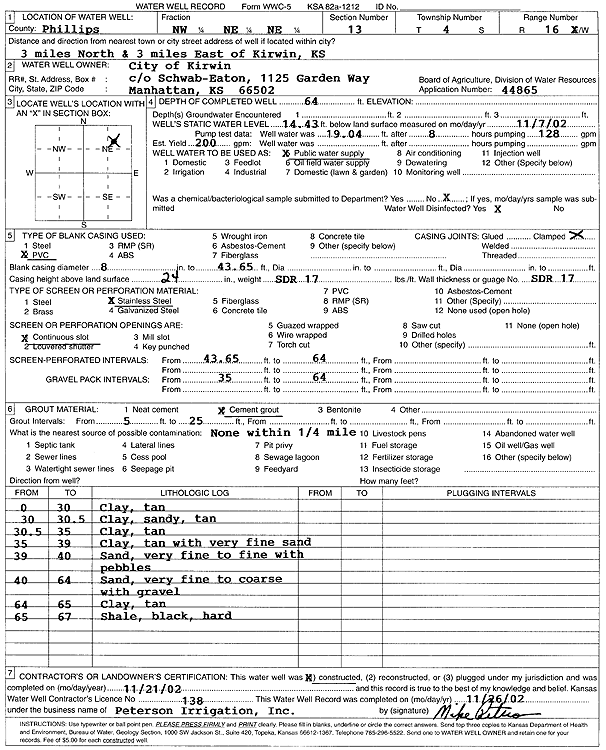
Specific Water Well Detail |
|
|
| Location Info | |||
| Owner: City of Kirwin | Status: Constructed | ||
| Location: T4S, R16W, Sec. 13, NW NE NE | County: Phillips | ||
| Directions: from Kirwin: 3 mi N, 3 mi E | |||
| Latitude: 39.7120762 | Longitude: -99.069509 | Datum NAD 27 | |
| Latitude: 39.7120871 | Longitude: -99.0698727 | Datum NAD 83 | |
| Longitude and latitude calculated by Survey from township-range-section-quarter calls. Only good to within the quarter call accuracy. | |||
| View well on interactive map | |||
| General Info | ||
| Well Depth: 64 ft. | Elevation: ft. | |
| Static Water Level: 14.43 ft. | Est. Yield: 200 gpm. | |
| Comp. Date: 21-Nov-2002 | Well Use: Public Water Supply | |
| DWR Applic. #: 44865 | Other ID: | |
| Links | |
| No Wizard information available. | |
| View info from WIMAS Water Right Data base... | |
| Driller Info | ||
| Driller: Michael Peterson Irrigation, Inc. | License #: 138 | |
| Scanned Form | View scan |
|
Chemical Sample Submitted?:
Water Well disinfected?: | ||
| Casing Info | ||
| Casing Type:
Casing Joints: |
Diam: in. to ft | |
| Casing height above land surface: in
Casing Weight: lbs/ft Wall thickness or gauge no.: | ||
| Screen and Perforation Info | ||
| Screen Type: | Screen Openings: | |
| Screen-perforated intervals | From: ft to ft | |
| Gravel pack intervals | From: ft to ft | |
| Grout Info | ||
| Grout used: | From: to ft | |
| Source of Possible Contamination | ||
| Source: | ||
| Direction from well: | Distance: ft | |
| Lithologic Log
(Log data entered by KGS.) | ||
| From: 0 ft. to 30 ft. | clay, tan | |
| From: 30 ft. to 30.5 ft. | clay, sandy, tan | |
| From: 30.5 ft. to 35 ft. | clay, tan | |
| From: 35 ft. to 39 ft. | clay, tan, with very fine sand | |
| From: 39 ft. to 40 ft. | sand, very fine to fine, with pebbles | |
| From: 40 ft. to 64 ft. | sand, very fine to coarse, with gravel | |
| From: 64 ft. to 65 ft. | clay, tan | |
| From: 65 ft. to 67 ft. | shale, black, hard | |