|
|
|
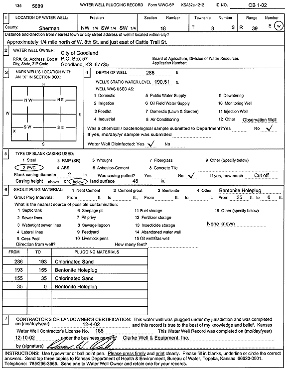
Specific Water Well Detail |
|
|
| Location Info | |||
| Owner: City of Goodland | Status: Plugged | ||
| Location: T8S, R39W, Sec. 18, NW SW SW | County: Sherman | ||
| Directions: from W 8th St: .25 mi N, just E of Cattle Trail St., Goodland | |||
| Latitude: 39.3538987 | Longitude: -101.72422 | Datum NAD 27 | |
| Latitude: 39.3538982 | Longitude: -101.7246705 | Datum NAD 83 | |
| Longitude and latitude calculated by Survey from township-range-section-quarter calls. Only good to within the quarter call accuracy. | |||
| View well on interactive map | |||
| General Info | ||
| Well Depth: 286 ft. | Elevation: ft. | |
| Static Water Level: 190.5 ft. | Est. Yield: gpm. | |
| Comp. Date: 04-Dec-2002 | Well Use: Monitoring well/observation/piezometer | |
| DWR Applic. #: | Other ID: OB 1-02 | |
| Driller Info | ||
| Driller: Clarke Well and Equipment, Inc. | License #: 185 | |
| Scanned Form | View scan |
| Casing Info | ||
|
Casing Type:
Diam: in. Casing height above land surface: in | ||
| Grout Info | ||
| Grout used: | From: to ft | |
| Source of Possible Contamination | ||
| Source: | ||
| Direction from well: | Distance: ft | |