|
|
|
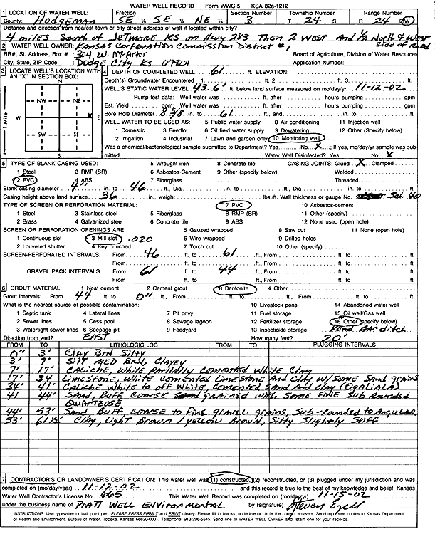
Specific Water Well Detail |
|
|
| Location Info | |||
| Owner: Kansas Corporation Commission Dist. 1 | Status: Constructed | ||
| Location: T24S, R24W, Sec. 3, SE SE NE | County: Hodgeman | ||
| Directions: from Jetmore: 4 mi S on Hwy 283, 2 mi W, .5 mi N, W side of Rd | |||
| Latitude: 37.9941137 | Longitude: -99.9369078 | Datum NAD 27 | |
| Latitude: 37.9941324 | Longitude: -99.9373162 | Datum NAD 83 | |
| Longitude and latitude calculated by Survey from township-range-section-quarter calls. Only good to within the quarter call accuracy. | |||
| View well on interactive map | |||
| General Info | ||
| Well Depth: 61 ft. | Elevation: ft. | |
| Static Water Level: 43.5 ft. | Est. Yield: gpm. | |
| Comp. Date: 12-Nov-2002 | Well Use: Monitoring well/observation/piezometer | |
| DWR Applic. #: | Other ID: | |
| Driller Info | ||
| Driller: Pratt Well Service, Inc. | License #: 665 | |
| Scanned Form | View scan |
|
Chemical Sample Submitted?:
Water Well disinfected?: | ||
| Casing Info | ||
| Casing Type:
Casing Joints: |
Diam: in. to ft | |
| Casing height above land surface: in
Casing Weight: lbs/ft Wall thickness or gauge no.: | ||
| Screen and Perforation Info | ||
| Screen Type: | Screen Openings: | |
| Screen-perforated intervals | From: ft to ft | |
| Gravel pack intervals | From: ft to ft | |
| Grout Info | ||
| Grout used: | From: to ft | |
| Source of Possible Contamination | ||
| Source: | ||
| Direction from well: | Distance: ft | |