|
|
|
Specific Water Well Detail |
|
|
| Location Info | |||
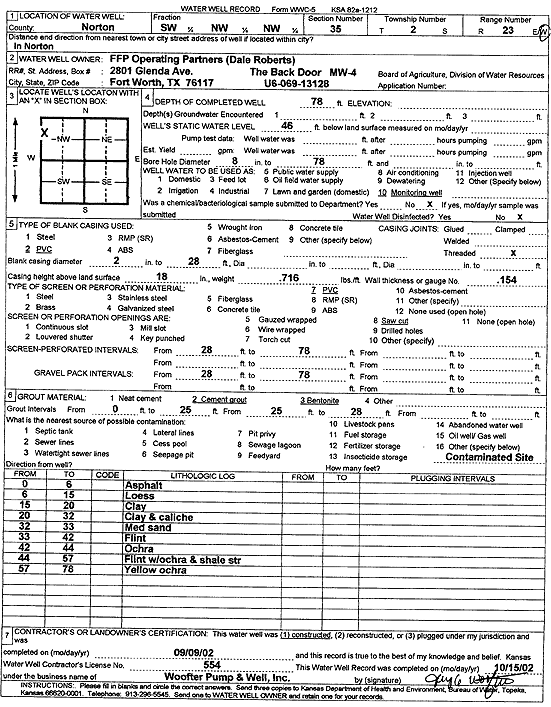
| Owner: FFP Operating Partners | Status: Constructed | ||
| Location: T2S, R23W, Sec. 35, SW NW NW | County: Norton | ||
| Directions: Norton | |||
| Latitude: 39.8394441 | Longitude: -99.8872347 | Datum NAD 27 | |
| Latitude: 39.8394498 | Longitude: -99.8876348 | Datum NAD 83 | |
| Longitude and latitude calculated by Survey from township-range-section-quarter calls. Only good to within the quarter call accuracy. | |||
| View well on interactive map | |||
| General Info | ||
| Well Depth: 78 ft. | Elevation: ft. | |
| Static Water Level: 46 ft. | Est. Yield: gpm. | |
| Comp. Date: 09-Sep-2002 | Well Use: Monitoring well/observation/piezometer | |
| DWR Applic. #: | Other ID: MW 4 | |
| Driller Info | ||
| Driller: Jay C. Woofter Pump & Well, Inc. | License #: 554 | |
| Scanned Form | View scan |
|
Chemical Sample Submitted?:
Water Well disinfected?: | ||
| Casing Info | ||
| Casing Type:
Casing Joints: |
Diam: in. to ft | |
| Casing height above land surface: in
Casing Weight: lbs/ft Wall thickness or gauge no.: | ||
| Screen and Perforation Info | ||
| Screen Type: | Screen Openings: | |
| Screen-perforated intervals | From: ft to ft | |
| Gravel pack intervals | From: ft to ft | |
| Grout Info | ||
| Grout used: | From: to ft | |
| Source of Possible Contamination | ||
| Source: | ||
| Direction from well: | Distance: ft | |
| Lithologic Log
(Log data entered by KGS.) | ||
| From: 0 ft. to 6 ft. | asphalt | |
| From: 6 ft. to 15 ft. | loess | |
| From: 15 ft. to 20 ft. | clay | |
| From: 20 ft. to 32 ft. | clay and caliche | |
| From: 32 ft. to 33 ft. | medium sand | |
| From: 33 ft. to 42 ft. | flint | |
| From: 42 ft. to 44 ft. | ochre | |
| From: 44 ft. to 57 ft. | flint with ochre and shale streak | |
| From: 57 ft. to 78 ft. | yellow ochre | |