|
|
|
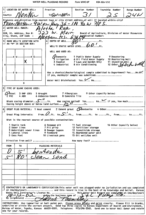
Specific Water Well Detail |
|
|
| Location Info | |||
| Owner: Rule, Aletha | Status: Plugged | ||
| Location: T2S, R24W, Sec. 31, SW NE | County: Norton | ||
| Directions: from Norton: 9 mi W on Hwy 36, 1 mi N, .5 mi W, .39 mi S | |||
| Latitude: 39.8367937 | Longitude: -100.0648113 | Datum NAD 27 | |
| Latitude: 39.8367989 | Longitude: -100.0652198 | Datum NAD 83 | |
| Longitude and latitude calculated by Survey from township-range-section-quarter calls. Only good to within the quarter call accuracy. | |||
| View well on interactive map | |||
| General Info | ||
| Well Depth: 80 ft. | Elevation: ft. | |
| Static Water Level: 60 ft. | Est. Yield: gpm. | |
| Comp. Date: 12-Oct-2002 | Well Use: Domestic, Livestock | |
| DWR Applic. #: | Other ID: | |
| Driller Info | ||
| Driller: S & L Pump Co. | License #: | |
| Scanned Form | View scan |
| Casing Info | ||
|
Casing Type:
Diam: in. Casing height above land surface: in | ||
| Grout Info | ||
| Grout used: | From: to ft | |
| Source of Possible Contamination | ||
| Source: | ||
| Direction from well: | Distance: ft | |