|
|
|
Specific Water Well Detail |
|
|
| Location Info | |||
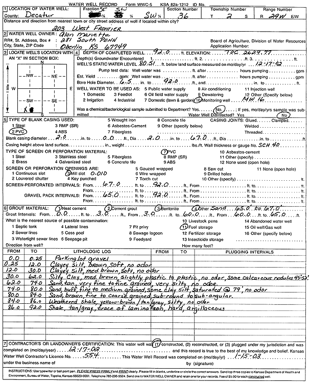
| Owner: Marietta, Alan | Status: Constructed | ||
| Location: T2S, R29W, Sec. 36, SE SW SW | County: Decatur | ||
| Directions: 203 W Frontier Pkwy | |||
| Latitude: 39.8289096 | Longitude: -100.5303246 | Datum NAD 27 | |
| Latitude: 39.8289148 | Longitude: -100.530748 | Datum NAD 83 | |
| Longitude and latitude calculated by Survey from township-range-section-quarter calls. Only good to within the quarter call accuracy. | |||
| View well on interactive map | |||
| General Info | ||
| Well Depth: 92 ft. | Elevation: 2629.77 ft. | |
| Static Water Level: 80.51 ft. | Est. Yield: gpm. | |
| Comp. Date: 17-Dec-2002 | Well Use: Monitoring well/observation/piezometer | |
| DWR Applic. #: | Other ID: MW 16 | |
| Driller Info | ||
| Driller: Jay C. Woofter Pump & Well, Inc. | License #: 554 | |
| Scanned Form | View scan |
|
Chemical Sample Submitted?:
Water Well disinfected?: | ||
| Casing Info | ||
| Casing Type:
Casing Joints: |
Diam: in. to ft | |
| Casing height above land surface: in
Casing Weight: lbs/ft Wall thickness or gauge no.: | ||
| Screen and Perforation Info | ||
| Screen Type: | Screen Openings: | |
| Screen-perforated intervals | From: ft to ft | |
| Gravel pack intervals | From: ft to ft | |
| Grout Info | ||
| Grout used: | From: to ft | |
| Source of Possible Contamination | ||
| Source: | ||
| Direction from well: | Distance: ft | |
| Lithologic Log
(Log data entered by KGS.) | ||
| From: 0 ft. to .3 ft. | parking lot gravel | |
| From: .3 ft. to 12 ft. | clayey silt, brown, soft, no odor | |
| From: 12 ft. to 30 ft. | clayey silt, medium brown, soft, no odor | |
| From: 30 ft. to 62 ft. | silty clay, medium brown slightly, plastic to plastic, no odor, some calcareous nodules at 45-50 feet | |
| From: 62 ft. to 74 ft. | sand, tan, very fine to fine grained, very silty, no odor | |
| From: 74 ft. to 80 ft. | sand, buff, fine to medium grained, some clay silty, saturated at 79 feet, no odor | |
| From: 80 ft. to 84 ft. | sand, brown, fine to coarse grained, sub-rounded to sub-angular | |
| From: 84 ft. to 86 ft. | weathered shale, yellow-brown/tan/gray, silty, no odor | |
| From: 86 ft. to 92 ft. | shale, tan/gray, trace of lamination, hard, argillaceous | |