|
|
|
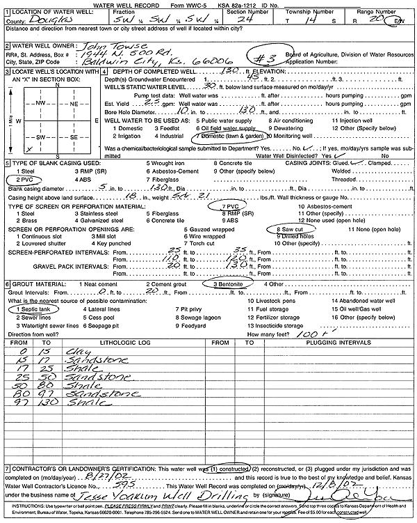
Specific Water Well Detail |
|
|
| Location Info | |||
| Owner: Towse, John | Status: Constructed | ||
| Location: T14S, R20E, Sec. 24, SW SW SW | County: Douglas | ||
| Directions: | |||
| Latitude: 38.8123893 | Longitude: -95.1478459 | Datum NAD 27 | |
| Latitude: 38.8123957 | Longitude: -95.1480942 | Datum NAD 83 | |
| Longitude and latitude calculated by Survey from township-range-section-quarter calls. Only good to within the quarter call accuracy. | |||
| View well on interactive map | |||
| General Info | ||
| Well Depth: 130 ft. | Elevation: ft. | |
| Static Water Level: 30 ft. | Est. Yield: 2.5 gpm. | |
| Comp. Date: 27-Aug-2002 | Well Use: Domestic, Lawn and Garden | |
| DWR Applic. #: | Other ID: Well 3 | |
| Driller Info | ||
| Driller: Jesse Yoakum Well Drilling | License #: 595 | |
| Scanned Form | View scan |
|
Chemical Sample Submitted?:
Water Well disinfected?: | ||
| Casing Info | ||
| Casing Type:
Casing Joints: |
Diam: in. to ft | |
| Casing height above land surface: in
Casing Weight: lbs/ft Wall thickness or gauge no.: | ||
| Screen and Perforation Info | ||
| Screen Type: | Screen Openings: | |
| Screen-perforated intervals | From: ft to ft | |
| Gravel pack intervals | From: ft to ft | |
| Grout Info | ||
| Grout used: | From: to ft | |
| Source of Possible Contamination | ||
| Source: | ||
| Direction from well: | Distance: ft | |
| Lithologic Log
(Log data entered by KGS.) | ||
| From: 0 ft. to 15 ft. | clay | |
| From: 15 ft. to 17 ft. | sandstone | |
| From: 17 ft. to 25 ft. | shale | |
| From: 25 ft. to 50 ft. | sandstone | |
| From: 50 ft. to 80 ft. | shale | |
| From: 80 ft. to 97 ft. | sandstone | |
| From: 97 ft. to 130 ft. | shale | |