|
|
|
Specific Water Well Detail |
|
|
| Location Info | |||
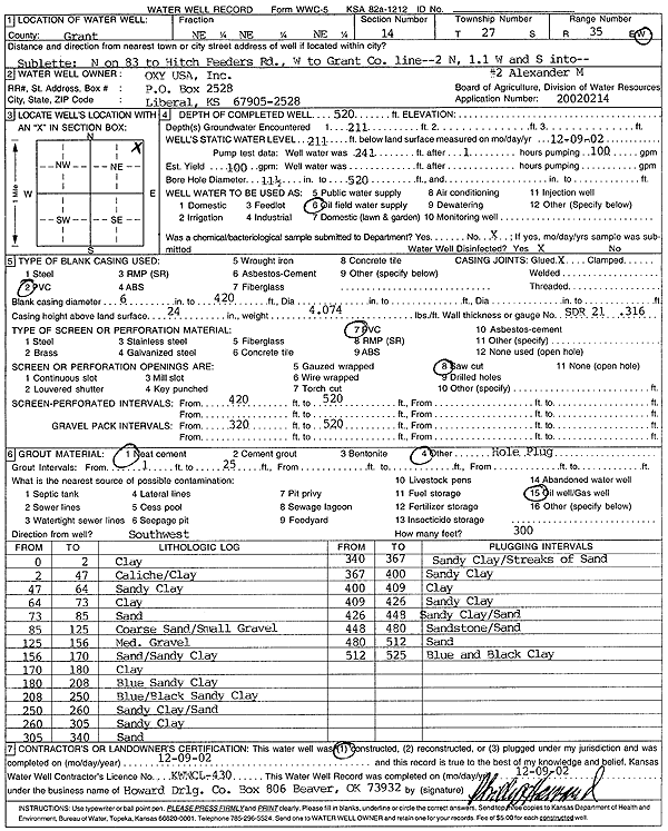
| Owner: Oxy USA, Inc. | Status: Constructed | ||
| Location: T27S, R35W, Sec. 14, NE NE NE | County: Grant | ||
| Directions: from Sublette: N on 83 to Hitch Feeders Rd, W to Grant Co. line, 2 mi N, 1.1 Mi W, S to site | |||
| Latitude: 37.706291 | Longitude: -101.1090452 | Datum NAD 27 | |
| Latitude: 37.7063128 | Longitude: -101.1094931 | Datum NAD 83 | |
| Longitude and latitude calculated by Survey from township-range-section-quarter calls. Only good to within the quarter call accuracy. | |||
| View well on interactive map | |||
| General Info | ||
| Well Depth: 520 ft. | Elevation: ft. | |
| Static Water Level: 211 ft. | Est. Yield: 100 gpm. | |
| Comp. Date: 09-Dec-2002 | Well Use: Oil Field Water Supply | |
| DWR Applic. #: 20020214 | Other ID: Alexander M 2 | |
| Links | |
| No Wizard information available. | |
| View info from WIMAS Water Right Data base... | |
| Driller Info | ||
| Driller: Howard Drilling Company AG, LLC | License #: 430 | |
| Scanned Form | View scan |
|
Chemical Sample Submitted?:
Water Well disinfected?: | ||
| Casing Info | ||
| Casing Type:
Casing Joints: |
Diam: in. to ft | |
| Casing height above land surface: in
Casing Weight: lbs/ft Wall thickness or gauge no.: | ||
| Screen and Perforation Info | ||
| Screen Type: | Screen Openings: | |
| Screen-perforated intervals | From: ft to ft | |
| Gravel pack intervals | From: ft to ft | |
| Grout Info | ||
| Grout used: | From: to ft | |
| Source of Possible Contamination | ||
| Source: | ||
| Direction from well: | Distance: ft | |
| Lithologic Log
(Log data entered by KGS.) | ||
| From: 0 ft. to 2 ft. | Clay | |
| From: 2 ft. to 47 ft. | Caliche/Clay | |
| From: 47 ft. to 64 ft. | Sandy Clay | |
| From: 64 ft. to 73 ft. | Clay | |
| From: 73 ft. to 85 ft. | Sand | |
| From: 85 ft. to 125 ft. | Coarse Sand/Small Gravel | |
| From: 125 ft. to 156 ft. | Med. Gravel | |
| From: 156 ft. to 170 ft. | Sand/Sandy Clay | |
| From: 170 ft. to 180 ft. | Clay | |
| From: 180 ft. to 208 ft. | Blue Sandy Clay | |
| From: 208 ft. to 250 ft. | Blue/Black Sandy Clay | |
| From: 250 ft. to 260 ft. | Sandy Clay/Sand | |
| From: 260 ft. to 305 ft. | Sandy Clay | |
| From: 305 ft. to 340 ft. | Sand | |
| From: 340 ft. to 367 ft. | Sandy Clay/Streaks of Sand | |
| From: 367 ft. to 400 ft. | Sandy Clay | |
| From: 400 ft. to 409 ft. | Clay | |
| From: 409 ft. to 426 ft. | Sandy Clay | |
| From: 426 ft. to 448 ft. | Sandy Clay/Sand | |
| From: 448 ft. to 480 ft. | Sandstone/Sand | |
| From: 480 ft. to 512 ft. | Sand | |
| From: 512 ft. to 525 ft. | Blue and Black Clay | |