|
|
|
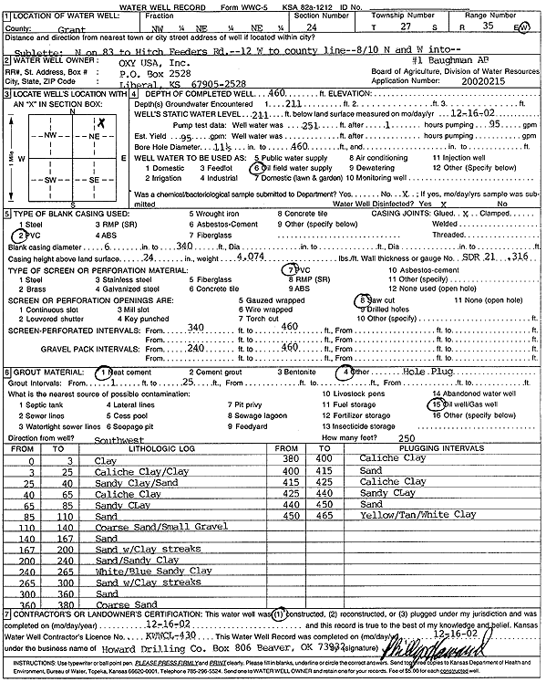
Specific Water Well Detail |
|
|
| Location Info | |||
| Owner: Oxy USA, Inc. | Status: Constructed | ||
| Location: T27S, R35W, Sec. 24, NW NE NE | County: Grant | ||
| Directions: from Sublette: N on 83 to Hitch Feeders Rd, 12 mi W to Co line, 0.8 mi N and W to site | |||
| Latitude: 37.6918248 | Longitude: -101.0930576 | Datum NAD 27 | |
| Latitude: 37.6918472 | Longitude: -101.0935052 | Datum NAD 83 | |
| Longitude and latitude calculated by Survey from township-range-section-quarter calls. Only good to within the quarter call accuracy. | |||
| View well on interactive map | |||
| General Info | ||
| Well Depth: 460 ft. | Elevation: ft. | |
| Static Water Level: 211 ft. | Est. Yield: 95 gpm. | |
| Comp. Date: 16-Dec-2002 | Well Use: Oil Field Water Supply | |
| DWR Applic. #: 20020215 | Other ID: Baughman AB 1 | |
| Links | |
| No Wizard information available. | |
| View info from WIMAS Water Right Data base... | |
| Driller Info | ||
| Driller: Howard Drilling Company AG, LLC | License #: 430 | |
| Scanned Form | View scan |
|
Chemical Sample Submitted?:
Water Well disinfected?: | ||
| Casing Info | ||
| Casing Type:
Casing Joints: |
Diam: in. to ft | |
| Casing height above land surface: in
Casing Weight: lbs/ft Wall thickness or gauge no.: | ||
| Screen and Perforation Info | ||
| Screen Type: | Screen Openings: | |
| Screen-perforated intervals | From: ft to ft | |
| Gravel pack intervals | From: ft to ft | |
| Grout Info | ||
| Grout used: | From: to ft | |
| Source of Possible Contamination | ||
| Source: | ||
| Direction from well: | Distance: ft | |
| Lithologic Log
(Log data entered by KGS.) | ||
| From: 0 ft. to 3 ft. | Clay | |
| From: 3 ft. to 25 ft. | Caliche Clay/Clay | |
| From: 25 ft. to 40 ft. | Sandy Clay/sand | |
| From: 40 ft. to 65 ft. | Caliche Clay | |
| From: 65 ft. to 85 ft. | Sandy Clay | |
| From: 85 ft. to 110 ft. | Sand | |
| From: 110 ft. to 140 ft. | Coarse Sand/Small Gravel | |
| From: 140 ft. to 167 ft. | Sand | |
| From: 167 ft. to 200 ft. | Sand with Clay streaks | |
| From: 200 ft. to 240 ft. | Sand/Sandy Clay | |
| From: 240 ft. to 265 ft. | White/Blue Sandy Clay | |
| From: 265 ft. to 300 ft. | Sand with Clay streaks | |
| From: 300 ft. to 360 ft. | Sand | |
| From: 360 ft. to 380 ft. | Coarse Sand | |
| From: 380 ft. to 400 ft. | Caliche Clay | |
| From: 400 ft. to 415 ft. | Sand | |
| From: 415 ft. to 425 ft. | Caliche Clay | |
| From: 425 ft. to 440 ft. | Sandy Clay | |
| From: 440 ft. to 450 ft. | Sand | |
| From: 450 ft. to 465 ft. | Yellow/Tan/White Clay | |