|
|
|
Specific Water Well Detail |
|
|
| Location Info | |||
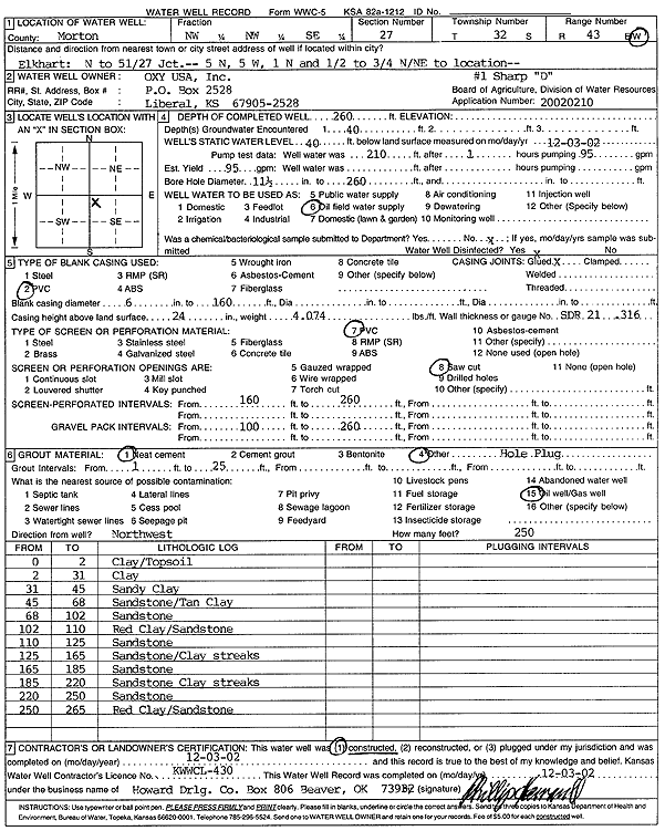
| Owner: Oxy USA, Inc. | Status: Constructed | ||
| Location: T32S, R43W, Sec. 27, NW NW SE | County: Morton | ||
| Directions: from Elkhart: N to 51/27 Jct., 5 mi N, 5 mi W, 1 mi N, .5 to .75 mi N/Ne to site | |||
| Latitude: 37.2351991 | Longitude: -101.9800564 | Datum NAD 27 | |
| Latitude: 37.235221 | Longitude: -101.9805055 | Datum NAD 83 | |
| Longitude and latitude calculated by Survey from township-range-section-quarter calls. Only good to within the quarter call accuracy. | |||
| View well on interactive map | |||
| General Info | ||
| Well Depth: 260 ft. | Elevation: ft. | |
| Static Water Level: 40 ft. | Est. Yield: 95 gpm. | |
| Comp. Date: 03-Dec-2002 | Well Use: Oil Field Water Supply | |
| DWR Applic. #: 20020210 | Other ID: Sharp D 1 | |
| Links | |
| No Wizard information available. | |
| View info from WIMAS Water Right Data base... | |
| Driller Info | ||
| Driller: Howard Drilling Company AG, LLC | License #: 430 | |
| Scanned Form | View scan |
|
Chemical Sample Submitted?:
Water Well disinfected?: | ||
| Casing Info | ||
| Casing Type:
Casing Joints: |
Diam: in. to ft | |
| Casing height above land surface: in
Casing Weight: lbs/ft Wall thickness or gauge no.: | ||
| Screen and Perforation Info | ||
| Screen Type: | Screen Openings: | |
| Screen-perforated intervals | From: ft to ft | |
| Gravel pack intervals | From: ft to ft | |
| Grout Info | ||
| Grout used: | From: to ft | |
| Source of Possible Contamination | ||
| Source: | ||
| Direction from well: | Distance: ft | |
| Lithologic Log
(Log data entered by KGS.) | ||
| From: 0 ft. to 2 ft. | clay/topsoil | |
| From: 2 ft. to 31 ft. | clay | |
| From: 31 ft. to 45 ft. | sandy clay | |
| From: 45 ft. to 68 ft. | sandstone/tan clay | |
| From: 68 ft. to 102 ft. | sandstone | |
| From: 102 ft. to 110 ft. | red clay/sandstone | |
| From: 110 ft. to 125 ft. | sandstone | |
| From: 125 ft. to 165 ft. | sandstone/clay streaks | |
| From: 165 ft. to 185 ft. | sandstone | |
| From: 185 ft. to 220 ft. | sandstone clay streaks | |
| From: 220 ft. to 250 ft. | sandstone | |
| From: 250 ft. to 265 ft. | red clay/sandstone | |