|
|
|
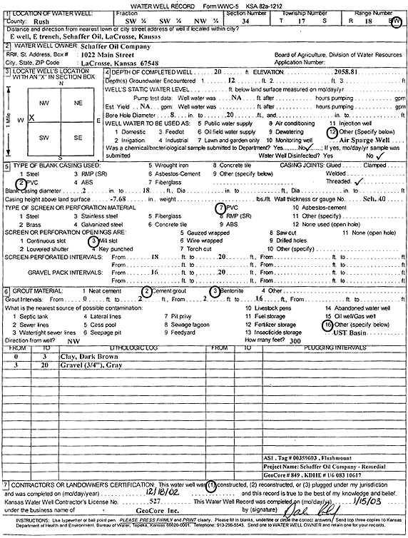
Specific Water Well Detail |
|
|
| Location Info | |||
| Owner: Schaffer Oil Co. | Status: Constructed | ||
| Location: T17S, R18W, Sec. 34, SW SW NW | County: Rush | ||
| Directions: E well, E trench, La Crosse | |||
| Latitude: 38.5324044 | Longitude: -99.3080189 | Datum NAD 27 | |
| Latitude: 38.5324177 | Longitude: -99.308401 | Datum NAD 83 | |
| Longitude and latitude calculated by Survey from township-range-section-quarter calls. Only good to within the quarter call accuracy. | |||
| View well on interactive map | |||
| General Info | ||
| Well Depth: 20 ft. | Elevation: 2058.81 ft. | |
| Static Water Level: ft. | Est. Yield: gpm. | |
| Comp. Date: 18-Dec-2002 | Well Use: Environmental Remediation, Air Sparge | |
| DWR Applic. #: | Other ID: AS 1 | |
| Driller Info | ||
| Driller: GeoCore Services Inc. | License #: 527 | |
| Scanned Form | View scan |
|
Chemical Sample Submitted?:
Water Well disinfected?: | ||
| Casing Info | ||
| Casing Type:
Casing Joints: |
Diam: in. to ft | |
| Casing height above land surface: in
Casing Weight: lbs/ft Wall thickness or gauge no.: | ||
| Screen and Perforation Info | ||
| Screen Type: | Screen Openings: | |
| Screen-perforated intervals | From: ft to ft | |
| Gravel pack intervals | From: ft to ft | |
| Grout Info | ||
| Grout used: | From: to ft | |
| Source of Possible Contamination | ||
| Source: | ||
| Direction from well: | Distance: ft | |
| Lithologic Log
(Log data entered by KGS.) | ||
| From: 0 ft. to 3 ft. | clay, dark brown | |
| From: 3 ft. to 20 ft. | gravel (0.75 inch), gray | |