|
|
|
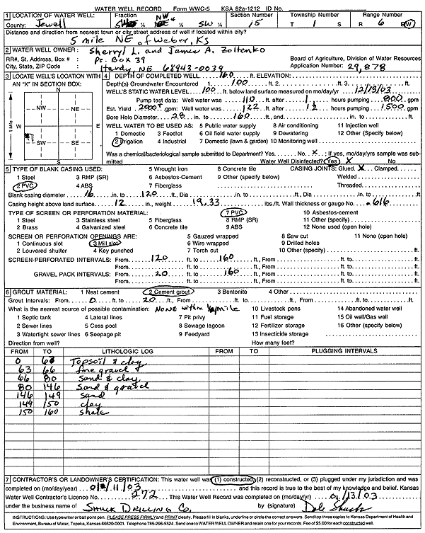
Specific Water Well Detail |
|
|
| Location Info | |||
| Owner: Zoltenko, Sherryl L. and Jamie A. | Status: Constructed | ||
| Location: T1S, R6W, Sec. 15, SW NW SW | County: Jewell | ||
| Directions: from Webber: 5 mi NE | |||
| Latitude: 39.9618046 | Longitude: -97.9871808 | Datum NAD 27 | |
| Latitude: 39.9618179 | Longitude: -97.9875021 | Datum NAD 83 | |
| Longitude and latitude calculated by Survey from township-range-section-quarter calls. Only good to within the quarter call accuracy. | |||
| View well on interactive map | |||
| General Info | ||
| Well Depth: 160 ft. | Elevation: ft. | |
| Static Water Level: 100 ft. | Est. Yield: 2000 gpm. | |
| Comp. Date: 11-Jan-2003 | Well Use: Irrigation | |
| DWR Applic. #: 29878 | Other ID: | |
| Links | |
| No Wizard information available. | |
| View info from WIMAS Water Right Data base... | |
| Driller Info | ||
| Driller: Dale Shuck Drilling Co. | License #: 272 | |
| Scanned Form | View scan |
|
Chemical Sample Submitted?:
Water Well disinfected?: | ||
| Casing Info | ||
| Casing Type:
Casing Joints: |
Diam: in. to ft | |
| Casing height above land surface: in
Casing Weight: lbs/ft Wall thickness or gauge no.: | ||
| Screen and Perforation Info | ||
| Screen Type: | Screen Openings: | |
| Screen-perforated intervals | From: ft to ft | |
| Gravel pack intervals | From: ft to ft | |
| Grout Info | ||
| Grout used: | From: to ft | |
| Source of Possible Contamination | ||
| Source: | ||
| Direction from well: | Distance: ft | |
| Lithologic Log
(Log data entered by KGS.) | ||
| From: 0 ft. to 63 ft. | top soil and clay | |
| From: 63 ft. to 66 ft. | fine gravel | |
| From: 66 ft. to 80 ft. | sand and clay | |
| From: 80 ft. to 146 ft. | sand and gravel | |
| From: 146 ft. to 149 ft. | sand | |
| From: 149 ft. to 150 ft. | clay | |
| From: 150 ft. to 160 ft. | shale | |